|
||

|

|
|

|
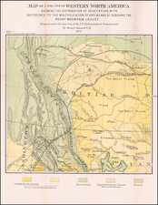
Every Man A Free Holder -- 320 Acres Free In The Devil's Lake, Turtle Mountain and Mouse River Country
Scarce promotional map for the St. Paul, Minneapolis & Manitoba Railway Company, published by Rand McNally.
The full title reads:
320 acres free in the Devil's Lake, Turtle Mountain and Mouse River Country in North Dakota: sectional map and full particulars inside.
Shows sections, counties, settlements, railroad in parts of Minnesota, North and South Dakota, Wisconsin and Manitoba. Inset: Map of the St. Paul, Minneapolis & Manitoba Railway, and connections.
The map focuses on the Red River Valley, which the map describes as "This Region Recently Opened For Settlement Is Unsurpassed In Agricultural Resources."
St. Paul, Minneapolis & Manitoba Railroad
The history of the St. Paul, Minneapolis & Manitoba, begins with James J. Hill, creator of the Great Northern. In 1856, at age 18, Hill left home and arrived in July, 1856 at St. Paul, where he began work as a shipping clerk in the office of a Mississippi River steamboat company. The Minnesota legislature, eager for rail lines in its territory, granted charters as early as 1853 and issued one in 1857 to the Minnesota & Pacific Railroad Company. The latter provided for construction of a line from Stillwater, Minn., on the St. Croix River, to St. Paul, St. Anthony (now Minneapolis) and Breckenridge, and another by way of St. Cloud to St. Vincent on the Canadian border.
There were delays and difficulties. The St. Paul & Pacific Railroad Company acquired the Minnesota & Pacific's rights, completed the first ten miles of construction in Minnesota -- from St. Paul to St. Anthony, now Minneapolis -- and began regular operations on July 2, 1862.
In 1865, Hill entered the transportation field on his own account, to represent a steamboat line connecting with east-bound rails at lower Mississippi River points. A year later he was agent for the First Division of the St. Paul & Pacific. By 1870, he was in a partnership doing general business in wood, coal and commissions, and in another to operate a steamboat service on the Red River of the North.
Success here preceded acquisition in 1878 of the St. Paul & Pacific, and the First Division, St. Paul & Pacific. Mr. Hill interested three men in joining him. One was Norman W. Kittson; the others were George Stephen, president of the Bank of Montreal, who became Lord Mount Stephen, and Donald A. Smith, chief commissioner of the Hudson's Bay Company, later to become Lord Strathcona. The latter two subsequently gained fame as pioneer railway builders in Canada.
The properties were reorganized in 1879 as the St. Paul, Minneapolis & Manitoba Railway Company. Settlers came. By 1881, the Manitoba company operated 695 miles of track. Rail reached west to Devils Lake, North Dakota by 1885, and on some north and south branches. Colonization progressed and traffic grew. Montana was reached in 1887 to connect with other lines operating to the Pacific Northwest.
On September 18, 1889, the name of the old Minneapolis & St. Cloud Railroad Company was changed to Great Northern Railway Company. The latter, on February 1, 1890, took over properties of the St. Paul, Minneapolis & Manitoba Railway Company.
Rarity
OCLC locates 1 copy (Yale).
Rand McNally & Co. is a large American map and navigation company best known for its annual atlases. The company got its start in 1856, when William Rand opened a print shop in Chicago. He was joined in 1858 by a new employee, Andrew McNally. Together, the men established their namesake company in 1868. Originally, the company was intended to print the tickets and timetables for the trains running to and through Chicago; their first railway guide was published in 1869.
By 1870, they had shifted from just printing to publishing directories, travel guides, and newspapers. Their first map appeared in 1872 in a railway guide. The map was produced using a new wax engraving method, a cheaper process that gave the company an edge.
By 1880 Rand McNally had entered the education market with globes, wall maps, and geography texts for students. In 1923, Rand McNally published the first Goode’s World Atlas, named after its editor, Dr. J. Paul Goode. For generations afterward, this would be the standard classroom atlas.
In 1899, William Rand left the company, but McNally and his family remained, controlling the company for over a century. In 1904, they published their first road map intended for automobiles and by 1907 were publishing Photo-Auto Guides, which combined photography and mapping to help drivers. In 1924, they produced the Auto Chum, a precursor to their famous road atlases. Rand McNally would remain the leader in road maps and atlases throughout the twentieth century.
In 1937, Rand McNally opened its first store in New York City. Ever on the frontier of technology, Rand McNally pioneered the scribing process for printing tickets in 1958 and printed their first full-color road atlas in 1960. Arthur Robinson developed his now-famous projection of Rand McNally in 1969. By the 1980s, the company was exploring digital reproduction and digital databases of maps for truckers. In the 1990s, they lead the charge to develop trip-planning software and websites. Today, most of its products are available online or in a digital format, including maps for tablets and phones.
![[First State of the Popple Key Sheet] A Map of the British Empire in America with the French and Spanish Settlements adjacent thereto by Hen. Popple.](https://storage.googleapis.com/raremaps/img/small/92714.jpg)