


|
||

|

|
|

|
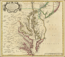
Single Sheet Depiction of Augustine Hermann's Map of the Chesapeake.
Finely colored example of the final staten of Christopher Browne's seminal depiction of the Chesapeake Bay, Delaware Bay, Virginia, Maryland, and parts of Pennsylvania and New Jersey. First engraved in 1685 and here re-issued for the final time by John Senex, the map serves as an exquisite example of the intricacies of early American cartography.
At its core, the map embodies the final major derivative of Augustine Hermann's iconic 4-sheet chart of 1673. Re-oriented with north at the top and reduced for practical use to a single folio sheet, the map popularized Hermann's otherwise virtually unobtainable depiction of the region, being one of the most successful maps of the region over its 4 decade run of publication.
This map is also noteworthy for its depiction of the contested boundaries of Maryland, Delaware (then part of Pennsylvania), and New Jersey. The Northern and Eastern frontiers of Maryland are distinctly presented, and Delaware's boundary leans towards Lord Baltimore's claims as opposed to the Cape Henlopen boundary proffered by the Penn Family. This demarcation is intriguing, considering that in resolving the Maryland-Pennsylvania boundary disputes, the British Courts would later confirm the Cape Henlopen boundary (favoring the Penn Family) during the dispute resolution in the 1730s, which was subsequently mapped by Mason & Dixon.
New Jersey, another key player in this cartographical depiction, is divided into East and West Jersey. The Hermann-inspired map meticulously portrays shoals and soundings, paying homage to its predecessor. Adding a touch of local flavor, the cartouche illustrates tobacco and shellfish, both of which were significant regional products during colonial times. Uniquely, this edition remains the only one to feature longitudinal lines at the top and bottom of the map.
Hermann's four-sheet map from 1673, the progenitor of this version, marked a significant milestone in the mapping of the Chesapeake and Delaware Bay region. Its groundbreaking level of detail and accurate depiction of shoals, rivers, and settlements not only served as a practical tool for navigation but also laid the foundation for subsequent cartographic works, like Browne's map.
In the early 18th century, the region depicted on this map was central to American commerce. As a hub of agricultural produce and maritime activity, the Chesapeake and Delaware Bay areas played significant roles in trade and transportation. Major products such as tobacco, shellfish, and other agricultural goods contributed to the region's economic growth and its commercial significance in the burgeoning American colonies. Ports in cities like Philadelphia and Baltimore provided important links for trade routes, enhancing the importance of accurate navigational charts. These factors underline the relevance of this map beyond its artistic and historical value, making it a crucial artifact for collectors interested in the Chesapeake region.
An essential map for Chesapeake regional collectors.
John Senex (1678-1740) was one of the foremost mapmakers in England in the early eighteenth century. He was also a surveyor, globemaker, and geographer. As a young man, he was apprenticed to Robert Clavell, a bookseller. He worked with several mapmakers over the course of his career, including Jeremiah Seller and Charles Price. In 1728, Senex was elected as a Fellow of the Royal Society, a rarity for mapmakers. The Fellowship reflects his career-long association as engraver to the Society and publisher of maps by Edmund Halley, among other luminaries. He is best known for his English Atlas (1714), which remained in print until the 1760s. After his death in 1740 his widow, Mary, carried on the business until 1755. Thereafter, his stock was acquired by William Herbert and Robert Sayer (maps) and James Ferguson (globes).

![(Carolinas) Virginiae Partis australis, et Floridae partis orientalis, interjacentiumqus regionum Nova Descriptio [A New Description of the Southern Part of Virginia and the Eastern Part of Florida, and the Intervening Regions.]](https://storage.googleapis.com/raremaps/img/small/94131.jpg)
![[St. Augustine, Florida] Beschreibung des Vorgebürgs Floride/ da die Franzosen anzufahren pflegen/welches von ihnen das Französische Vorgebürg genannt wirdt.](https://storage.googleapis.com/raremaps/img/small/84381.jpg)