|
||

|

|
|

|
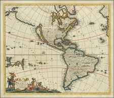
Scarce map of the Western Hemisphere from Bodenheur's rare Atlas Curieux.
This map was part of a comparative cartography section of the Atlas, which contrasted the mapping of the Western Hemisphere by the Dutch and the French.
This map shows California as an Island on the Sanson model, with the mythical land bridge to the right, called "Land von Jesso". South America is badly distorted. Primitive Great Lakes.
A partial New Zealand Coastline is present, along with Van Diemen's Land. An Outline of some of the Unknown Southern Continent is shown, south of Tierra del Fuego in the Antarctic region.
Gabriel Bodenehr the Elder (ca. 1673-ca. 1766) was a German engraver and publisher. He originated views of many German cities, for example the first plan of Passau (1710), and is best known for his Atlas Curieux (1704). His son, Gabriel the Younger (1705-1779), followed his father in his profession and was also a well-known engraver.
![[ First State of the First Map of America ] Novae Insulae XVII Nova Tabula](https://storage.googleapis.com/raremaps/img/small/94609.jpg)