This item has been sold, but you can enter your email address to be notified if another example becomes available.


|
||

|

|
|

|
Stock# 44902
Description
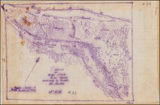
Mapping The Outside Lands Of San Francisco.
Interesting map created just after the lands to the west of the boundary of the 1851 Charter line were turned over to San Francisco following years of legal disputes.
Warren Heckrotte describes the map in some detail, noting that the map:
Shows the city from the Bay to Pacific Ocean and bounded in south by four league line (this runs a little north of Sloat from 15th Ave. to the Ocean), San Miguel Rancho and Bernal Rancho. The outside lands were the lands outside the boundary of the 1851 Charter line. All of the outside lands are laid out in streets. Each of the Committee members has a street named after him. A curious feature is that no. 7 in the list of institutions is City Hall and Library bounded by Portero and Nebraska and Nevada and Sierra Streets. Golden Gate Park is located but labeled only Park and Buena Vista Park is located but labeled only Park. There is an unlabeled dotted line that runs irregularly through what is the Sunset District and an unlabeled solid line that runs a different irregular line through the Sunset District which represents the Spring Valley Flume that came in from San Mateo County.
The map identifies the following members of Committee--each becoming a Street name in Haight Ashbury.
- Chas. H. Stanyan
- A.J. Shrader
- Beverly Cole
- Chas. Clayton
- Monroe Ashbury .
Condition Description
Laid on linen.
![[Northern San Diego County] Escondido Quadrangle](https://storage.googleapis.com/raremaps/img/small/83567.jpg)