This item has been sold, but you can enter your email address to be notified if another example becomes available.


|
||

|

|
|

|
Stock# 4488
Description
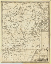
A detailed map of Philadelphia and Environs, based upon Faden's map. Extends North to include German Town, South to the Delaware River and East to Derby. Includes dozens of Roads, and shows the names of at least 100 landowners outside of Philadelphia proper. Names the townships, Islands and a number of other features. Notes a Chevaux de Frise which the Americans laid across the river from Mud Island to obstruct navigation. Many meeting houses shown. Large profile vignetter of the State House. A nice example of one of the earliest widely published maps of the Philadelphia area during the Revolutionary War. Nebenzahl Battle Plans #131; Snyder #46. A nice example in orginal color. Two minor wormholes are barely visible.
![[ New England / Northeast / Canada ] Tierra Nueva](https://storage.googleapis.com/raremaps/img/small/86737.jpg)