|
||

|

|
|

|
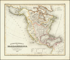
Fine example of this early state of Walch's rare map of North America, including a depiction of the State of Franklin (Franklinia), curiously placed between Kentucky and Virginia, pre-dating the appearance of Tennessee on this map.
The map provides an excellent treatment of the Northwest Coast of America and conjectural Northwest Passage, massive Quivira, interesting river system in the Northwest, predating the first report of Lewis & Clark's explorations, although with a detailed treatment of the information derived from Cook & Vancouver.
The depiction of the Missouri River is also of note.
Perhaps the most significant of the annotations are several references to Mr. Fidler, which traces the route of Peter Fidler (1769-1882), a 24 year old trader and surveyor with the Hudson Bay Company. Fidler travelled extensively in 1790-1792, through the region north of what was then believed to be the source of the Missouri River. The map notes Fidler's explorations to what was believed to be the headwaters of the Missouri River in 1792, which lay just to the southwest of the Hudson Bay Company's Buckingham House, Cumberland House, and Manchester House.
Fidler spent his career as a surveyor, map-maker, chief fur trader and explorer working for the Hudson's Bay Company in what later became Canada. Fidler joined the Hudson's Bay Company, first arriving at the York Factory in 1788. He was promoted to clerk and posted to Manchester House and South Branch House in what later became Saskatchewan, within his first year. In 1790, he was transferred to Cumberland House and given training in surveying and astronomy by Philip Turnor, who also trained David Thompson. On December 23,1788, Thompson had seriously fractured his leg, forcing him to spend the next two winters at Cumberland House convalescing. This gave Fidler the opportunity to accompany Turnor on an exploration expedition, to the west, from 1790 to 1792, attempting to find a route to Lake Athabaska and Great Slave Lake, and therefore a route to the Pacific Ocean. Although the river route to the west his employer sought was found not to exist, on this and following expeditions, Fidler gathered data for the first of several maps that he produced. Information he gathered was incorporated into the maps of North America produced by Aaron Arrowsmith, but as noted below, this appears to be the earliest appearance of Fidler's journey on a printed map.
Streeter discusses at length the importance of an 1801 manuscript copy of the Peter Fidler map as showing a knowledge of the Missouri sources "which was greater than the information of our geographers at the time" (referring to Fidler's use of information obtained from the Blackfoot Indians). Streeter also notes that the Fidler map was of great importance to Arrowsmith in drawing up his map of North America in 1802 (Streeter 249).
The map similarly notes "Vandriel 1791." John Cornelius Vandriel (Van Driel), was the North West Company clerk who was stationed at Ile-a-la-Cross in 1788-89, and Athabasca in 1789-90. Vandriel had some knowledge of Surveying, likely learned from MacKenzie, who sent him to make surveying observations on the road to the Grand Portage in 1790. After leaving the North West Company, Vandriel worked for 5 years for the Hudson Bay Company, where he travelled as far as the Cumberland House. Curiously, the only source we could locate which discusses Vandriel at any length, suggests that he returned briefly to London in the fall of 1790 and did not return to Canada until 1792. It is more likely that this information derives from Vandriel from South Branch House, dated June 22, 1794.
Johann, or Johannes, Walch (1757-1816) was a painter and engraver. He was well-known for painting miniature portraits, having trained in Geneva, Venice, and Rome. Walch published several atlases and sheet maps. As with his atlases, many of Walch’s maps were reprinted after his death.
![Oceani Occidentalis Seu Terrae Novae Tabula [The Admiral's Map]](https://storage.googleapis.com/raremaps/img/small/102935.jpg)
![A New Mapp of America Septentrionale . . . 1669 [California shown as an island]](https://storage.googleapis.com/raremaps/img/small/94304.jpg)
![[ Chinese Voyages To America, etc. ] Memoires De Litterature, Tires Des Registres De L'Academie Royale Des Inscriptions et Belles-Lettres Depuis l' annee M. DCC. XVIII. julques & compris l'annee M. DCC. XXV Tome Quarante-Neuvieme](https://storage.googleapis.com/raremaps/img/small/101296.jpg)