|
||

|

|
|

|
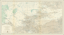
First British Survey Map of the Source of the Ganges River in the Himalayas.
Fascinating map of part of Uttarakhand, based upon the surveys of Lieutenant W.S. Webb.
This map was the product of the first attempt to survey and explore the source of the Ganges River. In 1808, Robert Colebrooke planned to explore the source of the Ganga (Ganges) in Garhwal, but was not able to undertake the expedition due to illness and died in the same year. John Garstin succeeded him as Surveyor-General of Bengal. The expedition work was continued by William Webb, Captain Felix Raper, and Hyder Hearsey who produced the first map of the Bhagirathi Valley. They also sent Hearsey's Hindu munshi (assistant) to Gangotri and incorporated his observations in their final report (published in Asiatic Researches, volume 11, 1810), which demonstrated that the source of Ganga lay within the Himalaya, not in Lake Manasarovar in southern Tibet, as was then widely believed.
An important antique map for the earliest scientific Survey of the Himalayas, etc.
![[ Andhra Pradesh ] Map of the Roads From Nellore to the Passes of Rampore and Samisserum and to Ongole by Caolin Mackenzie, Practr. Engineer 1788 . . .](https://storage.googleapis.com/raremaps/img/small/62194.jpg)