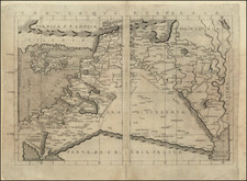
|
||

|

|
|

|
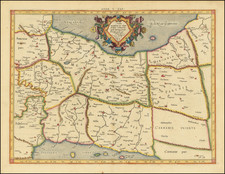
Municipal Water and Electrical Delivery Map for the Republic of Iraq.
Large format separately issued map of the Republic of Iraq, showing the progress of the delivery of water and electricity to municipalities throughout Iraq, published by the Directorate General of Municipalities in 1959 and printed by the Survey Press in Baghdad.
The map divides Iraq into 14 provinces and then identifies the extent of water and electrical service in the primary roughly 10 to 20 municipalities in each of the provinces. A symbol identifies whether the municipality (marked with an O), has muncipal water, municipal electricity, none or both.
At the bottom right, a table track the Revenues and Expenditures associated with these services between 1941 and 1957.
The map would seem to show the progress of the Municipal improvement projects in Iraq commenced under King Faisal II (1935-1958), but apparently continued following overthrow of the Hashemite monarchy on July 14, 1858 and establishment of the Republic of Iraq.
The portrait at the top right shows Abd al-Karim Qasim (1914 - 1963), the Iraqi Army brigadier general who seized power in July 1858 and ruled Iraq as Prime Minister until his downfall and death during the 1963 Ramadan Revolution.
The map is extremely rare. We note several extent photocopies and originals for maps published in 1955, 1956 and 1957 bearing similart titles, but this later 1959 edition seems to be unrecorded and would certainly have been revised, at minimum, to rename the country (Republic of Iraq) and show the portrait of its new Prime Minister (Qasim).