|
||

|

|
|

|
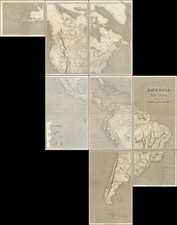
Interesting map of America, showing a very early primitive border with Canada (British Columbia), from just after Lewis & Clark's explorations. Mexico is still a Spanish Vice Royalty. A very unusual Nouvelle Albion appears on the map in the coastal region between SF Bay and the Columbia River, one of the few and rare delineated examples of an English 19th Century Claim on the NW Coast. The NW Coast reflects the still unknown detail north of the Columbia. Alaska is Russian America. Some odd state configurations east of the Mississippi, especially in the South. Lots of Indian Tribes named. The apocryphal rivers from California to Lake Timpanagos and the Rocky mountains are shown. Louisiana Territory still dominates the mid-continent. A striking example of this fine map. Wonderful detail in Canada and near the artic circle.