|
||

|

|
|

|
Rare Old Color Example of Volney's Map of the United States.
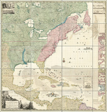
Important map of the United States, issued by C.F. Volney to accompany his Tableau du Climat et du Sol des Etats-Unis D'Amérique. Suivi d'éclaircissemens sur la Floride, sur la colonie Française au Scioto, sur quelques Canadiennes et sur les Sauvage, published by Corcier - Dentu in Paris in 1822.
This important 2 volume work was one of the earliest scholarly works on the United Statee. The map illustrates Volney's route through the United States (in Yellow).
The map includes remarkable details on some of the Indian Tribes in the Southeastern US, including the number of Warriors in the Criks, Choctas and Chicasas Indian Nations. Georgia is shown as Eastern and Western Georgia (Orientale and Occidentale), Kentokey is shown, as is Tennesie. Nice detail in the Ohio and Missisippi Valleys, including notes on the topography, Indians and other details.
Volney
Constantin François de Chasseboeuf, comte de Volney (1757 - 1820), was a French philosopher, abolitionist, historian, orientalist, and politician. In 1795 he undertook a journey to the United States, where he was accused by John Adams' administration of being a French spy sent to prepare for the reoccupation of Louisiana by France and then to the West Indies. Consequently, he returned to France. The results of his travels were published in his Tableau du climat et du sol des États-Unis (1803).
![(Lasalle's Final Expedition) Dernieres Decouvertes dans L'Amerique Septentrionale de M. De La Sale [i.e., La Salle], Mises au jour par M. le Chevalier Tonti, Gouverneur du Fort Saint Louis, aux Islinois.](https://storage.googleapis.com/raremaps/img/small/69476.jpg)