This item has been sold, but you can enter your email address to be notified if another example becomes available.


|
||

|

|
|

|
Stock# 43419
Description
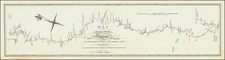
Scarce early map of Kentucky, published in London in 1795.
An excellent topographical map, showing settlements, trails, roads, Indian boundaries and Indian Towns.
This edition of the map appeared in A Topographical Description of the Western Territory of North America. . . , by Gilbert Imlay, published in London in 1795.


![Carte De La Louisiane Et Du Cours Du Mississipi . . . Juin 1718 [1st State!]](https://storage.googleapis.com/raremaps/img/small/59797.jpg)