|
||

|

|
|

|
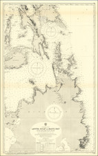
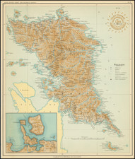
Highly detailed Spanish Hydrographical Department Survey chart of the southern part of the Philippines.
The chart covers the southeastern part of Mindanao and Basilan Island.
The chart was prepared under the direction of Claudio Montero, who served as Admiral of the Spanish Royal Navy and oversaw the survey of the Philippines in the 1860s.
The Dirección de Hidrografía, or the Directorate of Hydrographic Works, was established in 1797. Its roots were in the Casa de Contratación, founded in 1503 in Sevilla, which housed all the charts of the Spanish Empire and oversaw the creation and maintenance of the padrón real, the official master chart. The Casa, now in Cadiz, was shuttered in 1790, but Spain still needed a hydrographic body. In response, the Dirección was created in 1797. One of its first projects was the publication of charts from the Malaspina Expedition (1789-1794). The Dirección oversaw not only publication, but also surveying. The Dirección was abolished in the early twentieth century, when their work was distributed to other organizations.