|
||

|

|
|

|
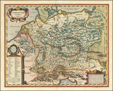
A rare and historically important early 18th Century wall map of Bohemia, by the priest-surveyor Johann Georg 'Mauritius' Vogt (1669 -1730).
This magnificent and very rare wall map is one of the seminal works of the historical cartography of Bohemia. It is the first printed map to be based on the groundbreaking surveys of the priest-surveyor Mauritius Vogt and it presents by far the most accurate and detailed mapping of the province to date. Every city, town, village and major road is labeled, the boundaries of the regions (kraje) are demarcated and all major forests and rivers are depicted.
The 'Explicatio Signorum', or legend, in the upper right corner, details numerous attributes of Bohemia's human geography, including Urbs Munita (fortified cities), Civitas (cities), Oppidum (towns), Arx (forts), Monasterium (monsteries), Pagus (villages), Capella (abbeys), Arx Ruinata (ruined forts), Monast. Ruinatum (ruined monasteries), Posta (postal stations), Mola (mills), Archi Ep. (archbishops' seats), Episc. (bishops' seats), Studium (colleges), Telonium (toll houses on roads).
Bohemia was also long known as one of the most productive mining areas in Europe, such that the map labels Aurifodina (gold mines), Argentifodina (silver mines), Stanifod. (tin mines), Cuprif. (copper mines), Thermes (springs / baths), Officina vitri (glassworks), Vineae (vineyards) and Fodina Ferri (iron mines). No other map to date presented anywhere near as detailed an overview of Bohemia, and as such the map is today a treasure-trove for scholars of period Czech history and geography.
Otherwise the corners of the map are lavishly adorned, in the upper right stands the Bohemian Lion rampant; in the lower left resides allegories personifying Bohemia's fourteen main rivers; while the lower right corner features the title cartouche surrounded by scenes of agricultural and hunting bounty.
Johann Georg (commonly known as 'Mauritius') Vogt (Czech: Jan Jirí 'Moric' Vogt) (1669-1730) was a late Baroque era polymath. He was born in Königshofen, Bavaria, but moved to Bohemia at a young age to attend Charles University in Prague, where he studied philosophy and theology. During the generations following the Thirty Years' War (1618-48) the ruling Habsburg regime in Bohemia, encouraged many devoutly Roman Catholic Bavarians to assume ecclesiastical positions in Bohemia as part of an ongoing programme to prevent the feared revival of Protestantism in the province. Under these circumstances, in 1692, Vogt was sponsored to join the Abbey of Plasy, near Plzen, where he was ordained a Cistercian monk in 1698.
During his time at Plasy Vogt became fascinated by the history and geography of the region. Over two decades he conducted many advanced surveys of the Bohemian countryside that he eventually fashioned into the present map. In 1712, he sent his finished manuscript to Nuremberg, then by far the most important map printing centre in Central Europe, to be engraved by Jan Leonard Blanck and published by Johann Zieger. At Zieger's urging, Vogt also published an insightful written treatise on the geography of Bohemia,
Das jetzt lebende Königreich Böhmen in seiner historisch- und geographischen Beschreibung vorgestellt (Frankfurt and Leipzig, 1712).
Vogt's map was dramatically more detailed and planimetrically accurate than its predecessors, notably Jacob Sandrart's Bohemia in suas partes geograph: distinc: (1666). His endeavor was only superseded by Johann Christoph Müller's gargantuan map of Bohemia of 1720.
A genius gifted in many disciplines, apart from his contributions to cartography, Vogt was a well-known musician who was considered to be the most virtuous organist in Bohemia. He published a fine treatise on music,Conclave thesauri magnae artis musicae (1719). He resided at Plasy until 1724, when he was promoted to become the superior of the pilgrimage church of Mariánská Týnice, where he died in 1630.
Vogt's map of Bohemia proved to be highly influential and was widely copied, especially by the major Southern German cartographers, throughout much of the 18th Century.
The present map represents the first time that Vogt's groundbreaking surveys appeared in print. It is thus one of the seminal maps of Bohemia and a cornerstone of any collection of Czech cartography. The survival rate of early 18th century wall map is remarkably low, and today the Vogt map is very rare. We can locate only one appearance of the map at auction during the last generation and no instances of the map being offered in dealers' catalogues during the same period.