


|
||

|

|
|

|
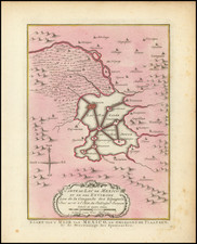
Rare separately issued chart of the harbor at Vera Cruz, as surveyed by Bernardo Orta in 1798.
The chart was of such importance that it was later re-issued on a smaller scale by Alexander von Humboldt.
Orta's chart shows the coast of Mexico and the city of Veracruz, numerous offshore islands, desired routes of approach, and various soundings. A lengthy note in the upper left corner provides tips for entering the harbor.
The chart was prepared under the direction of Bernardo Orta, captain of the Spanish Royal Armada stationed in Veracruz.
The Dirección de Hidrografía, or the Directorate of Hydrographic Works, was established in 1797. Its roots were in the Casa de Contratación, founded in 1503 in Sevilla, which housed all the charts of the Spanish Empire and oversaw the creation and maintenance of the padrón real, the official master chart. The Casa, now in Cadiz, was shuttered in 1790, but Spain still needed a hydrographic body. In response, the Dirección was created in 1797. One of its first projects was the publication of charts from the Malaspina Expedition (1789-1794). The Dirección oversaw not only publication, but also surveying. The Dirección was abolished in the early twentieth century, when their work was distributed to other organizations.

![[Mexico]. Descripcion Del Destricto Del Audiencia De La Nueva Galicia](https://storage.googleapis.com/raremaps/img/small/64950.jpg)
![[Florida Panhandle to Yucatan] Pas-Kaart Van de Golff van Mexico . . .](https://storage.googleapis.com/raremaps/img/small/93130.jpg)
![(Mexican-Aztec Paintings) [Original watercolor of 4 Aztec Deities:] Atlcaualoc. Tlaloc, God of Water; Tlacaxipeualitztli, God of Soldiers; Tocozintli, God of Abundance; Veitozcoztli, God of First Fruits.](https://storage.googleapis.com/raremaps/img/small/103005.jpg)