|
||

|

|
|

|
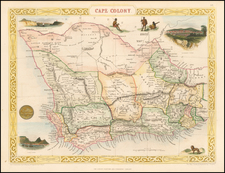
Scarce folding map of South Africa and neighboring regions, published in London by George Philip & Son.
The map shows colonies and Free-states in 1898. The two green areas on the map are the Portuguese colonies of Angola (on the left), and Mozambique (on the right). The rest of the map is controlled by the British Empire or soon to be controlled by them.
Namibia is on the left hand side right under Angola and on its right is Matabeleland, modern day Zimbabwe. On the far right is the Orange Free State (marked in yellow) and above it is the Southern African republic (blue). Between these two and Namibia is Bechuanaland modern day Botswana. Bechuanaland was incorporated into Cape Colony in 1895 by the British who at this point have colonized most of Southern Africa.
Under the title there is two distance keys, one in miles and the other in kilometers. The map contains various topographies such as rivers, lakes, deserts and mountains. It has main roads, regions, cities, and ports marked. All that is salmon color is under the Union Jack's rule. In another three years the Orange Free State and the Southern African Republic will be joining them.
In 1898, the scramble for Africa was going strong, most European countries had acquired various amounts of land in Africa. With major world powers dividing up Africa and wanting more it is not surprising that some issues arise. In 1898, the Fashoda Incident was the climax of imperial territorial disputes between Britain and France in Eastern Africa. A French expedition to Fashoda on the White Nile river sought to gain control of the Upper Nile river basin and thereby excluding Britain from the Sudan. The two expeditionary armies met on friendly terms but back in Europe it became a war scare. The British and French held firm as Britain and France were on the verge of war with heated rhetoric on both sides. Under heavy political pressure the French withdrew, securing Anglo-Egyptian control over the area. This was a case of diplomacy and resolution with-out blood spilled on the other hand in 1898 in the region that is the map above another problem was brewing.
In 1880, there was the first Boer war which lasted only one year and was a defeat for Britain. After a significant gold deposit find, a second war for the territory was waged by the British. In 1899, the Second Boer war started, and unlike the previous one where there was only a couple hundred casualties, this one was to be far bloodier. Many tens of thousands were killed by disease, conflict or by the Empires use of concentration camps. The war was won by the British Empire, and both republics were annexed into the Union of South Africa in 1910.
This map shows the various territories before they were all incorporated in one South Africa and made part of the empire.
![[South African Republic, Orange Free State, Natal, Basutoland, etc.] The Absent-Minded Beggar](https://storage.googleapis.com/raremaps/img/small/78441.jpg)
![[Southwestern Coast of Africa] Pas-Caart van Guinea en de Custen daer aen gelegen Van Cabo verde tot Cabo de Bona Esperanca](https://storage.googleapis.com/raremaps/img/small/46931.jpg)