|
||

|

|
|

|
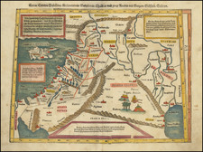
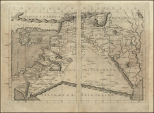
Detailed map of Assyria, Syria, Armenia Cyprus, etc., based upon the work of Ptolemy and other authors.
Centered on Babylon and Palmyra, the Tigres and the Eurphrates.
At the bottom of the map we can see three bodies of water, on the right is the Persian Gulf then on the bottom left is the Arabian Gulf and above it along the coast of Syria is the Mediterranean Sea. The island of Cyprus is shown in the Mediterranean, right under the title. There are borders illustrated by dotted lines and they separate the various states shown; Armenia, Mesopotamia, Syria, Assyria, Persia, Palestine, Phoenicia, Media, and Babylonia. Two main rivers are drawn the Euphrates and Tigris. The Zagros Mountains are portrayed around Armenia and going down to the Persian Gulf, and the Arabian Desert takes up most of the lower half of the map. Not All the cities located on the map existed at the same time, and some still exist.
The map depicts the Near East at around 600 A.D., during this time period Rome still exists as the Byzantine Empire. In 627, the forces of the Byzantine emperor defeated the forces of the Sassanid Empire. The victory saved the Byzantine Empire from further Persian attack. In the Near East Persians start to use windmills for irrigation, and Christianity spreads to Arabia where the province of Najran becomes Christian, but not for long. The seventh century though is most noted for the rise and spread of Islam.
In 570 the prophet Muhammad was born and he starts preaching in 610 first in Mecca and then in Medina. From Medina, he unites the tribes of Arabia under the banner of Islam and creates a single Islamic state. In 630, Muhammed organizes the commonwealth of Islam in and around Mecca. A series of battles was fought between Mecca and Medina. Under the Trewaty of Hudaybiya, Muhammad's followers were finally given the right to undertake pilgrimages to Mecca. But when this right was denied them, they took control of the city.
Two years later Muhammad died and Abu Bakr became the first Caliph. Two years later he also dies and his successor Omar I, the sword of God, expands the Caliphate throughout the Arabian Peninsula. He defeats first the Sassanid's and conquers Persia, in 638. Later, Jerusalem surrenders and the Byzantines are defeated. In 642 the Arabs conquer Egypt. By this time the whole peninsula shown on the map is under Arab rule. By the End of the 7th century, the whole peninsula had an established postal service, was using Arab coins, Muslim and was organized as one unified caliphate that stretches from Tunis to Afghanistan. By the year 750 the Umayyad caliphate stretches from Spain to Pakistan it's largest extant to be reached.
Pierre Duval (1618-1683) was a French geographer, cartographer, and publisher who worked in Abbeville and Paris during the seventeenth century. He was born in the former city, in northeast France, before moving to Paris. Duval was the nephew of the famous cartographer Nicolas Sanson, from whom he learned the mapmaker's art and skills. Both men worked at the royal court, having followed the royal request for artists to relocate to Paris. In addition to numerous maps and atlases, Du Val's opus also includes geography texts. He held the title of geographe ordinaire du roi from 1650 and died in 1683, when his wife and daughters took over his business.