|
||

|

|
|

|
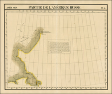
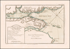
Rare Russian Hydrographical Department map and report regarding the search of Sir John Franklin and English explorations in the Arctic Regions, which appeared in Morskoi sbornik, Volume 3, No. 10, published in St. Petersburg in October, 1850.
The map extends from the Northwestern Coast of Russia and Russian America (Alaska) to Baffin Bay, showing known and conjectural coastlines, straits, bays, etc. The map illustrates an article which, according to the US Coast & Geodetic Survey, appears at pp 316-334 in this issue of the journal and is described as "The English Expedition in Bering strait."
The map references discoveries in 1819, 1822, 1830, 1839, 1847 and 1849. The 1849 discovery is Henry Kellet's discovery of Herald Island, to the east of Wrangel Island In1849. Henry Kellett, captain of HMS Herald, landed on and named Herald Island. He thought he saw another island to the west, which he called Plover Island; thereafter it was indicated on British admiralty charts as Kellett Land (now Wrangel Island).
On page 381, a section begins on the search for Franklin, who was then still lost in the Polar Sea. On page 382, there is a list of 10 expeditions made by British ships, each of whom made an effort to find Franklin, but which had, to date, been unsucessful, including a list noting the number of men on each expedition. This first 10 are expeditions made north from the Atlantic Ocean.
On page 383, there is separate list of expeditions, including Kellett's, made from the Pacific Ocean, via the Bering Straits. In this section is a note that Captain Richard Collinson has written from Sandwich Islands with the news that Capt. Kellett had set off for the Bering Strait in 1850 and was intending a reconnaissance of the Cape of Lisburn, and that despite the distance of 3800 miles, he was hoping to get there before August 15 to meet up with Captain Horatio Thomas Austin near Melville Island. This is also were Captain William Penny and the Americans were planning to winter.
The writer concludes that it was not known whether these various 1850 expeditions had reached their destination or not, with further commentary about the so far fruitless search for traces of Franklin.
First published by the Russian Imperial Navy in 1848, this monthly scientific naval journal was published well into the 1980s.
We find references made to the pamphlet and map in the United States Coast & Geodetic Survey's 1879 Pacific Coast Pilot: Coast and Islands of Alaska. Second Series, Partial List of Charts and Maps Relating To Alaska, &c. p. 73 and Publications on Alaska and Adjacent Regions, p. 312 (The English Expedition in Bering strait; with a map).
The pamphlet is apparently quite rare. We locate no examples at auction and only one example of any edition of the Moroskoi sbornik (1855) offered for sale at auction in the last 30 years (as reported by Americana Exchange). This is the first time we have ever seen the map. Curiously, we were also not able to locate any references to this section of text as being part of the known Franklin search references in the above mentioned Pacific Coast Pilot or otherwise.
![[ Antarctica ] [Signed and Annotated by Robert A. English, Commanding Officer of the Bear of Oakland] Reconnaissance Map. King Edward VII Land. The Northern Part of Marie Byrd Land. Based mainly on air photographs taken by Capt. A.C. McKinley on the Byrd Antarctic Expedition 1928-1930 . . .](https://storage.googleapis.com/raremaps/img/small/89439.jpg)