|
||

|

|
|

|
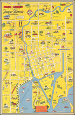
Fine promotioal pictoral plan of the island of Key West, drawn by artist Theodore Leisen Jr.
The map provides an overview of the town and its primary points of interest, including Meacham Field, the Yacht Club, Naval Base, West Martello Tower, Salt Ponds, etc.
The verso provides a schematic map of the "World Famous Overseas Highway" from Barnes Sound (Key Largo) to Key West.
The key locates 21 activities and points of interest, half of which are detailed on the verso. The front also includes a nice historic overview of Key West, dating back to Spanish times.
A rare and appealing promotional map, issued shortly after the completion of the "Overseas Highway" in 1922.
We can find nothing on Leisen, although there is an interesting article in the Pittsburg Post-Gazette (September 14, 1929), noting that Leisen, a commercial artist, his bride, and architect Frank Clark of New York City, were the subject of a search in Norwalk, Connecticut, with the police fearing foul play (the wife had formerly been married to a man named O'Neill, a member of the Vanderbilt family.
![(Florida Aviation - Early Photographs) [Original photograph album of Carlstrom Field, Florida, early Army Air Service Training Camp]](https://storage.googleapis.com/raremaps/img/small/84163.jpg)
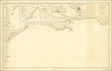
![[Florida/Georgia -- Mouth of St. Mary's River] Plan of Amelia Island In East Florida; A Chart of The Entrance Into St. Mary's River; A Chart of The Mouth of Nassau Rivers. By Captain William Fuller. 1770](https://storage.googleapis.com/raremaps/img/small/40410.jpg)