|
||

|

|
|

|
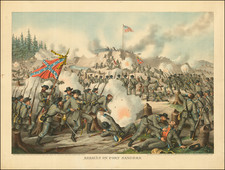
Defence of Fort Morgan, August 1864
The Defence of Fort Morgan maps, authored by Brigadier General P.L. Page, P.A.C.S., in August 1864, present a significant historical record of the Confederate defensive strategies at Fort Morgan during a crucial phase of the American Civil War. The maps offer a meticulous depiction of military positions and points of interest at the "Entrance of Mobile Bay," chronicling the intense conflict faced by the Confederacy in the face of Union advances.
The primary map details the fort's perimeter defenses and internal configurations at a time when the Civil War was at its zenith. The cartographic precision in illustrating the fort's batteries, magazines, and defensive structures emphasizes the stronghold's strategic importance in safeguarding the pivotal port of Mobile Bay. As such, the map serves both as a military document and a geographical challenge faced during the war.
A key that enumerates 30 points of interest, ranging from navigational aids to sites of shipwrecks, each contributing to the understanding of the fort's operational scope and the broader narrative of Mobile Bay's defense. This legend provides insights into the fort's utility, the nature of its fortifications, and moments of conflict within the bay, capturing a snapshot of the theater's complexity.
Integral to these maps is the color key, which employs a spectrum of hues to delineate the stages of military maneuvers over several critical nights in August 1864. This chromatic guide is essential for decoding the sequence of Confederate and Union activities, illustrating the siege's progression with distinct colors corresponding to specific dates. The use of color in this way showcases the strategic significance of visual elements in military planning and record-keeping.
The maps together reveal the tactical considerations of Confederate forces and the art of cartographic intelligence in the mid-19th century.
The map was included in a rare 1878 book entitled The Battle of Mobile Bay, and the Capture of Forts Powell, Gaines and Morgan, by the Combined Sea and Land Forces of the United States . . . August, 1864, by Foxhall A. Parker. There were apparently 2 maps included in a pocket in the back of the book.
Rarity
RBH notes a single example of the book in the past 100 years (Goodspeed, 1954).
OCLC locates 7 examples of the book.
![(The First Letter From British Florida) [September 5, 1763, Autograph Letter, Signed, from Robert Campbell to John Campbell, 4th Earl of Loudoun, describing the British taking possession of Florida and the state of the settlement of Pensacola]](https://storage.googleapis.com/raremaps/img/small/86620.jpg)
![(Three Days at Gettysburg) Map of the Battlefield of Gettysburg July 1st, 2nd, 3rd 1863. . . [Three Maps]](https://storage.googleapis.com/raremaps/img/small/101769.jpg)
![[ French Louisiana ] Carte De la Louisiane par Le Sr. D'Anville Dressee en Mai 1732. Publiee en 1752](https://storage.googleapis.com/raremaps/img/small/88804.jpg)