|
||

|

|
|

|
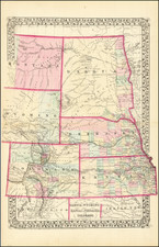
Highly detailed map of Eastern Montana and Western North Dakota . published for Henry B. Carrington's The Indian Question. An Address . . . , published in Boston in 1884.
The map illustrates one of the privately printed works of Carrington. Henry Beebee Carrington (1824 -1912) was a lawyer, professor, prolific author, and an officer in the United States Army during the American Civil War and in the Old West during Red Cloud's War. A noted engineer, he constructed a series of forts to protect the Bozeman Trail, but suffered a major defeat at the hands of the warchief Red Cloud.
Following the Civil War, the 18th Infantry was stationed in the West. Carrington was then assigned as commander of the Mountain District, Department of the Missouri, in 1866 and moved his regimental headquarters to Colorado. Assigned to protect the Bozeman Trail, he built and personally manned the remote Fort Phil Kearny during Red Cloud's War. Carrington soon lost the respect of his officers due to his lack of aggressiveness in several Indian skirmishes. In December 1866, a force of up to fifteen hundred Indians attacked a wood-cutting detail, then overwhelmed a reaction force of eighty troops under Captain William J. Fetterman. Fetterman, one of Carrington's antagonists, disobeyed his order not to pursue the Indians too far from the fort. Fetterman's force was lured into an ambush and annihilated with no survivors.
Fetterman's popularity, coupled with existing distrust of the Carrington's leadership, led to rumors that his men had been ordered into the tragedy. General Ulysses S. Grant moved to court-martial Carrington but, at the suggestion of General William T. Sherman, submitted the matter to a court of inquiry, which subsequently exonerated Carrington, as did a separate investigation by the Department of the Interior. Nevertheless, Carrington had been relieved of command immediately after the disaster, so that his military career was effectively ruined.
Carrington's earliest reports on the Phil Kearny Massacre were initially surpressed by General Ulysses S. Grant at the time it was originally received in the War Department, but were later published with the permission of General Sherman in Margaret I Carrington's Absaraka, in 1868.
The present map extends form Montana City, Silver City and Camp Baker in the Northwest, Salt Lake City, Fort Bridger and Coalville in the Southwest, Omaha, Nebraska City and Council Bluff in the southeast and Burlington (Dakota Territory), Silomonee and Ft. Abercrombie in the Northeast.
This is the first time we have ever seen the map on the market.


![[Mormon Trail] Utah And the Overland Routes to it, from the Missouri River: Published with](https://storage.googleapis.com/raremaps/img/small/66366.jpg)