
This item has been sold, but you can enter your email address to be notified if another example becomes available.


|
||

|

|
|

|
Stock# 40305
Description
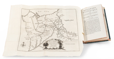
Scare and highly sought after map of Michigan, based upon David Burr's map of 1834, with corrections.
The present example is from the 1849 edition of Greenleaf's Atlas.
Marquette, Delta Schoolcraft, Chippewa and Michilimackinac County appear in the Upper Peninsula, and the Township of Michillimacinac is present. While previously, the Ottawas & Miamies had dominated the northern part of the state, this area is now subdivided into counties.
The Boundary Line established by the Saginaw Treaty is shown, A number of Indian Villages are named. The map includes towns, early counties, roads, rivers, lakes, forts, and other notes.
Condition Description
Faded.

![[ Michigan & 3 Great Lakes ] Amer. Sep. No. 42 Haut Canada Et Michigan](https://storage.googleapis.com/raremaps/img/small/98409.jpg)


