|
||

|

|
|

|
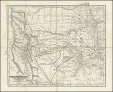
Rare early edition of Page's detailed map of Colorado, issued sometime shortly after the establishment of Pitkin County and Dolores County, Colorado, in February 1881.
Page's map is one of the largest and most detailed early maps of Colorado to appear in a Commercial Atlas. The map shows the extent of theTownship surveys, and includes towns, mountains, rivers, forts, mines, roads, railroads etc.
We note that later editions which we have handled, dated 1885 and 1887, show significant county progression. As such, it is clear that Page was regularly updating this map.
This is also the only edition of the map we have seen which includes the mining vignette at the left side of the map.
The earliest example we have ever handled. Copyright date 1880.


![[ California & Southwest ] Granata Nova Et California](https://storage.googleapis.com/raremaps/img/small/72305.jpg)