This item has been sold, but you can enter your email address to be notified if another example becomes available.


|
||

|

|
|

|
Stock# 3945
Description
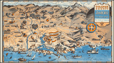
Interesting map of teh Monterey Peninsula, showing the 17 mile drive, towns, hotels, golf courses, airport, Sardine Fleet, Wharf, Lovers Point, Seal Rock, Bird Rock, Fan Shell Beach, Cypress Point, Sunset Point, Midway Point, Fishing Club Bathing Beach, Pebbler Beach, Arch Rock Marine Garden, Carmel Point, Point Lobos, the San Simeon Highway, various toll gates, etc. A folding promotional for the hotel, with a map of the route from San Luis Obispo to Carmel via highway 1 and highway 101, plus details on the Del Monte and Pebble Beach. A terrific item of ephemera.
![(Early California Trade) [Royal Decree of October 22,1803, to encourage trade in California]. D. Joseph de Yturrigaray, Caballero profeso de la Orden de Santiago, Teniente General de los Reales Exércitos, Virrey, Gobernador...Con fecha de 22 de Octubre del año proximo anterior...la Real Orden...Con objeto de fomentar la Agricultura y Comercio de las Californias, se ha servido el Rey habilitar sus Puertos en calidad de menores...](https://storage.googleapis.com/raremaps/img/small/93851.jpg)