|
||

|

|
|

|
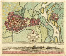
Rare map of the region centered on the region between the Loire River, Rhone River and Saone River, published in Lyon by Philippe Le Beau.
The present map is likely the earliest surviving map to focus in detail on this region. It is also likely the prototype map for subsequent maps by Tassin, Hondius and others. The map has been described by Francoise de Dainville as "inconnue" (unknown) in his essay Deux cartes inconnues du Lyonnais, Forez et Beaujolais 1596-1623(?). With the exception of this brief note by Dainville and citations thereto, the map appears to be, as indicated by Dainville, completely unknown and unrecorded. There is no similar map in the first national atlas of France, Le Theatre Francois, published in 1594 by Maurice Bouguereau in Tours, which contained 20 maps, of which only 3 (Blaisois, Touraine, & Limousin) are original maps, the rest being drawn from Mercator, Ortelius and others.
The present map would appear to have influenced the subsequent maps of Tassin, etc., although these later maps show significantly improved cartographic detail and accuracy. The "footprint" of the map, its orientation and the area covered are virtually identical, suggesting that Le Beau's map was likely the original prototype from which these maps are derived.
Philippe Le Beau, was a well regarded mathematician resident in Lyon. Le Beau would later serve as geographer to the King and is perhaps best known for his large manuscript map of Lyon of 1606-07. The map includes a lengthy dedication to King Henry IV and sets out to delineate the region in significant detail, including its boundaries and barriers.
The map is oriented with west at the top and includes 2 coats of arms, (1) the coat of arms of France and Navarre, following the ascent of King Henry IV, King of lower Navarre, to the throne of France in 1589, and (2) the coat of arms of Lyon.
Lyon appears the bottom center of the map, with Feurs and Montbrison near the top. St. Etienne, Roanne, Marsigny, Charlleu, Villefranche-sur-Saone, Macon, Belleville, St. Chamond, Chazelles-sur-Lyon and Vienne, are among the other larger cities shown.
![(French Naval Dry Docks) Marine, Plan des Formes Baties a Rochefort pur la Construction des Vaisseaux du Roy [Navy, Plan of Locks Built at Rochefort for the Construction of Royal Vessels]](https://storage.googleapis.com/raremaps/img/small/88594.jpg)