|
||

|

|
|

|
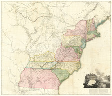
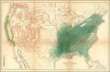
Rare separately issued map of the United States, published by SA Mitchell Jr. in Philadelphia.
While many American publishers capitalized on the huge public demand for separately published war maps during the Civil War, the firm of SA Mitchell remained remarkably inactive in this genre.
The present map is a fascinating study of the use of existing maps to create a new map. The primary map of the United States employs an early map of the US issued by Mitchell in 1861 and 1862, shortly after the creation of Nevada Territory, Colorado Territory and the short lived Arizona Territory (configured below New Mexico--the so-called "Baylor LIne."). Dakota Territory is shown in its largest configuration, as is Washington Territory, which would shortly give up its eastern extremes to the newly formed Idaho Territory. Nebraska Territory is also shown in a short lived configuration, the western portion of which would become southern Wyoming Terrirtory after the Civil War.
To this base map, Mitchell adds two other regional maps from his New General Atlas, the short-lived map of Virginia and North Carolina (which would be abandoned for a larger format map of just Virginia, Maryland and Delaware, the following years). Of note, in the latter map, is the inclusion of the DC inset, which replaces the Philadelphia inset that normally appears on this map. Similarly, the inset of Hampton Roads, which appears between the 2 maps, was not employed on either atlas map.
Along the upper sides, Mitchell draws on inset maps for New Orleans, Baltimore and Richmond, which had been utilized on his earlier separately published maps of the United States.
The whole, along with new tables, is surrounded by a unique decorative border not previously associated with any of Mitchell's maps. The employment of the table of statistics from the census of 1850 and 1860, shows numbers of free and slave persons in sixteen states. This map illustrates the increase in slavery in the country during the decade before the war. Almost all the slave states saw dramatic increases in the number of slaves. At a time when politicians were emphasizing preservation of the Union, this form of information also advanced the cause of emancipation.
The map is quite rare, this being the first example we have seen on the market.
Samuel Augustus Mitchell Jr. inherited the Mitchell Company from his father in 1860. For over thirty years, the company had specialized in the production of school atlases and wall maps of America. They were one of the pioneers on engraving on steel plates. In 1860, Samuel Jr. released the New General Atlas, which had been compiled in house and replaced a previous atlas by Tanner. The elder Mitchell died in 1868 and Samuel Jr. continued the business until the 1890s. At its height, the Mitchell Company employed 250 people and sold 400,000 publications annually.
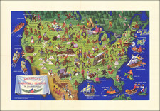
![Trails: [1595-1945]: Land, Sea, and Air of The American Adventure Series](https://storage.googleapis.com/raremaps/img/small/70672.jpg)