|
||

|

|
|

|
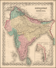
Detailed map of the northernmost part of India and Pakistan, lying between Kandahar and Tibet.
The map appeared in James Rennell's Memoir of a map of Hindoostan; or, The Mogul empire: with an introduction, illustrative of the geography and present division of that country: and a map of the countries situated between the heads of the Indian rivers, and the Caspian Sea, published in London, in 1792.
Rennell's maps are among the most important and infuential works on India published in the second half of the 18th Century. James Rennell (1742 to 1830) was an English Geographer and Historian, and a pioneer in the study of Oceanography. Rennell began his career in the English navy. He first travelled to India in 1760. He soon mastered the theory and practice of marine surveying and briefly worked for the East India Company, in the Philippines, drawing several maps for James Dalrymple.
At the end of the Seven Years' War, he signed on with the East India Company. He came to the attention of Governor Vansittart, who wished to initiate a survey of the British territory in India. Rennell was appointed surveyor-general of the East India Company's dominions in Bengal, with a commission in the Bengal Engineers in 1763. His survey of Bengal commenced in 1764, and for the next 13 years he surveyed vast amounts of British India, earning the nickname of the Father of Indian Geography. His career in the field ended when he was wounded in Bhutan.
![Russian Empire [with] Chart of the Communication Between The Archipelago And Black Sea](https://storage.googleapis.com/raremaps/img/small/64013.jpg)
![[ Black & Caspian Sea Region ]. Tabula Asiae III [](https://storage.googleapis.com/raremaps/img/small/76322.jpg)