|
||

|

|
|

|
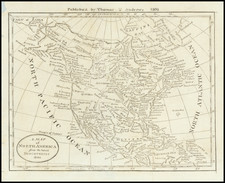
Exceedingly rare Irish edition of Herman Moll's celebrated "Codfish map" of North America, printed in Dublin by George Grierson.
This special edition of this highly decorative large-format map of North America and the West Indies is populalry known as the "Codfish Map", due to its adornment with a large engraving of fishermen catching and drying Cod along the shores of Newfoundland. It is one of the maps most beloved by connoisseurs, and was first issued by Herman Moll in his atlas The World Described (London, 1715). However, the present edition was published by Geoerge Grierson about 1735 in Dublin. Exceptionally rare, this Dublin edition is a major monument in Irish printing, being one of the first large-format maps printed in Ireland, part of an ambitious project launched by the leading Irish publisher.
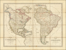
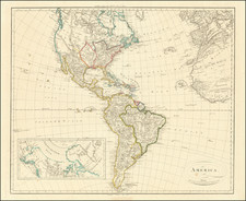
This highly-attractive map extends from Greenland in the north, down to the Spanish Main, along the northern shores of South America. It extends westward to include the Pacific coasts and eastward all the way to include Ireland, on the opposite side of the Atlantic. The map is an excellent overview of how the British conceived of North America and the West Indies during the first half of the 18th Century. As relatively few new surveys and voyages of exploration of note occurred between 1700 and 1750, this view remained relatively static, chronologically sandwiched between two feverish periods of mapping and discovery.
The British colonies along the Atlantic Seaboard are relatively well-mapped, based on late 17th-century cartography, although curiously, New England is shown to be exaggeratedly narrowed, especially evident in Massachusetts. The cartography becomes more rudimentarily as one moves north into the Canadian Maritimes, Quebec and Newfoundland, where Moll only had access to outdated French sources. Hudson's Bay is generally well formed, due to the charting done consistently since the 1660s for the benefit of the Hudson's Bay Company. Notably, the map labels the tracks of several sea voyages into the Bay and the adjacent Canadian Arctic Archipelago, to the north.
Further inland, things become quite interesting with the appearance of the mythical 'Long River' connecting the Mississippi River with points in the far west. As stated on the map, these details are derived from Louis Armand, Baron de Lahontan, a notorious French adventurer and fraudster who claimed to have discovered this waterway in the 1690s. He included the detail on a map within his bestseller Nouveaux Voyages dans l'Amerique Septentrionale (1703). The 'Long River' was adopted by most of the leading mapmakers of the time, including Guillaume de L'Isle, the mapmaker to Louis XIV and Moll.
Generally, the Great Lakes and the Mississippi are relatively well formed, based on French and Jesuit sources. In the southwest, New Mexico and the Rio Grande are shown in a roughly accurate fashion. California is prominently depicted to be an island, including the note that "New Albion" was discovered by Sir Francis Drake in 1578, a detail included by Moll, who was an ardent partisan of the British cause. Curiously, even after Padre Kino had proved that California was a part of the North American mainland in 1701, Herman Moll continued to be a strong believer in the 'California as an Island' myth, asserting that he had even been visited in his "office mariners who have sailed round it." The Pacific Northwest is labeled as "Parts Unknown", although it shows the mouth of the apocryphal 'Straits of Anian', a hoax concocted in 1706, which proposes a version of the fabled Northwest Passage.
The depiction of the West Indies and the Spanish Main is conventional for the period and features the tracks of the Spanish 'Flota', or fleets of treasure galleons, from Veracruz, Panama and Cartagena, to Havana and then onwards across the Atlantic to Seville. Moll was personal friends with many of the leading British privateers of the era and maintained a particular interest in potential targets for state-sanctioned piracy.
A very curious and notable aspect of the map is the depiction of the prevailing trade winds, in the manner pioneered by the brilliant English scientist and thematic cartographer, Sir Edmund Halley (1656-1742). Moll, a friend of Halley, was well aware that comprehending these phenomena was crucial to having an appreciation of Trans-Atlantic trade.
The left side of the composition features a veritable pageant of artistic embellishments. In the center is the famous aforementioned 'Codfish View'. Far beyond being a mere artistic conceit, it is symbolic of the Codfish industry of Newfoundland, which since 1713 was dominated by the British and was the second largest source of wealth from North America, rivaled only by Virginia's tobacco crop.
Below are a series of 10 vignettes of plans of key New World ports, including: St. John's, Newfoundland; Boston; New York; Charleston, South Carolina; Port Royal & Kingston, Jamaica; Havana; Portobello, Panama; Veracruz, Mexico; Cartagena, Colombia and Acapulco, Mexico (importantly the western terminus of the Spanish 'Manila Galleons', which travelled across the Pacific between Mexico and the Philippines).
The magnificent late English Baroque cartouche in the upper-left corner of the map is framed by figures of Native Americans and Inuit, while the treasures of the continent lie below. Within the cartouche itself, replacing Moll's original dedication, Grierson dedicates the map to Hugh Boulter (1672-1742), who served as Lord Archbishop of Armagh, the Anglican Primate of All Ireland, from 1724 until his death. Boulter was also the chaplain to King George I from 1719 to 1727. As Grierson was a major printer of bibles and other religious texts, the archbishop would have been one of his most important and longest-standing clients. Boulter's coat of arms surmounts the cartouche.
Herman Moll (1654-1732) was one of the most important cartographers working in England during the late 17th and early 18th Century. Originally from Germany, he immigrated to England in 1678 and made his name as an engraver for the likes of Christopher Browne, Robert Morden and Philip Lea. His first publication in his own name to feature maps was A System of Geography (1701).
This was followed by Fifty-six new and accurate maps of Great Britain (1708) and the Atlas Geographus (1711-17). His greatest masterpiece, The World Described (1715), contained 30 large maps and ran into numerous editions. Highlights of the atlas included the "Codfish Map" and the "Beaver Map" (an edition of which was also made by Grierson).
Notably, Moll made close friends in the naval and maritime community, such as the pirate-intellectual William Dampier. From this Moll developed a particular fascination with British overseas trade and privateering, lending his maps a unique and fascinating flavor.
George Grierson: Pioneering Irish Publisher
George Grierson (c.1678 - 1753) was one of the most important publishers, editors and mapmakers in 18th Century Ireland. Born in Dumfriesshire, Scotland, he immigrated to Ireland as a young man and in 1703 founded a printing house in Dublin at "The Sign of the Two Bibles" in Essex Street.
Dublin was then one of the most important cities in the British Empire, being a bustling port and a financial and services center. However, it had a relatively underdeveloped publishing sector. Up to this point, printing had been hampered by ongoing political instability throughout the 17th Century, a relatively strict regime of official censorship and the overwhelming market dominance of London printers. Especially with respect to cartographic printing, Dublin's footprint was miniscule, with even most surveys of Ireland being printed in England. Grierson boldly stepped into the void and more than any other figure transformed Dublin into a major printing hub.
Much misinformation has been written about Grierson. Indeed, from reading much of the material written in catalogs and on the internet, one gains the erroneous impression that he was an intellectual property "pirate" and some sort of disreputable fly-by-night journeyman printer. In reality, he was the leading publisher in Ireland and a highly respected member of the Dublin upper sets, as well as innovative and risk-taking entrepreneur. While he printed works originated by others, he always did this within copyright laws and always with attribution. In this sense, he was no different than any mapmaker who issued their own edition of a map previously issued (a common and well accepted norm).
Grierson started out printing Bibles and other religious texts but eventually moved into printing classics and literature. He produced important editions of Milton's Paradise Lost and Jonathan Swift's Gulliver's Travels. His series of affordable pocket-sized books, Grierson's Classics, were bestsellers of the era.
At one point in the 1720s, he hired Constantia Crawley (1705-32), a young and exceptionally brilliant classical scholar and poet. They were married in 1727 and the charismatic Constantia did much to improve the public reception of the hardworking but comparatively taciturn Scotsman. Following Constantia's untimely death, Grierson solidified his dominance of Irish publishing upon marrying Jane Blow, the daughter of James Blow, Belfast's leading printer.
In 1729, Grierson was appointed to become the "King's Printer" for Ireland, a highly lucrative and honorific post, in which capacity he was responsible for printing all parliamentary and government papers.
His first major foray into cartography was his publication of the first Irish edition of Sir William Petty's atlas of Ireland (1732), originally issued in London in 1685.
Following the death of the leading London cartographer Herman Moll (1654-1732), Grierson set about producing Irish editions of Moll's maps which were no longer under copyright.
As noted by Dennis Reinhartz in The Cartographer and the Literati - Herman Moll and his Intellectual Circle:
"…two editions of [Moll's Large Atlas] The World Described... were done by the Dublin publisher George Grierson... all of the maps in the Irish editions were completely re-engraved, even to the point of understandably having been rededicated to contemporary Irish notables. The Grierson atlas had new and/or changed cartouches, dedications, details, and comments. It also showed obvious erasers and additions, and some of the maps were updated."
Many of these maps (such as the present map) were exceedingly large and preparing the copper-plates was a major technical undertaking never before attempted in Ireland. This explains why some of Grierson's editions may appear to be somewhat crude in style compared to the London editions. Far from being due to carelessness, these imperfections are due to the growing-pains of attempting something bold and ambitious in a new setting.
While his editions of Moll's maps were likely also issued separately, Grierson issued complete editions of Moll's atlas, The World Described. Ashley Baynton-Williams, the foremost authority on maps published in the British Isles, reports that only two examples of the Grierson edition of The World Described are recorded. One example is to be found in the collections of the Royal Geographic Society (London) and the other at the Library of Trinity College (Dublin), although it is not known if these atlases are complete.
Grierson followed this up with his own edition of Mount & Page's sea atlas, The English Pilot (1749), being the first sea atlas printed in Ireland.
George Grierson died in 1753, but his printing business was continued by his family for some generations. Grierson was succeeded in the business by his son Boulter Grierson, who notably reissued his father's edition of the English Pilot in 1767. The Grierson firm continued to operate for the next three generations.
George Grierson's edition of the "Codfish Map" represents a major monument in the history of cartography printed in Ireland and a fine example of one of the period's most beloved maps. The map exists in two known states: the first state (exemplified by the present map), features the dedication to Hugh Boulter, Lord Archbishop of Armagh, while on the second state the dedication is removed, for reasons that are not known. All of George Grierson's maps are rare, with his editions of the "Codfish Map" being especially so. We are aware of only one other example as having appeared on the market during the last 25 years.
George Grierson (c.1678 - 1753) was one of the most important publishers, editors and mapmakers in 18th Century Ireland. Born in Dumfriesshire, Scotland, he immigrated to Ireland as a young man and in 1703 founded a printing house in Dublin at "The Sign of the Two Bibles" on Essex Street.
Dublin was then one of the most important cities in the British Empire, being a bustling port and a financial and services center. However, it had a relatively underdeveloped publishing sector. Up to this point, printing had been hampered by ongoing political instability throughout the 17th Century, with a relatively strict regime of official censorship and the overwhelming market dominance of London printers. Especially with respect to cartographic printing, Dublin's footprint was minuscule, with even most surveys of Ireland being printed in England. Grierson boldly stepped into the void and more than any other figure transformed Dublin into a major printing hub.
Much misinformation has been written about Grierson. Indeed, from reading much of the material written in catalogs and on the internet, one gains the erroneous impression that he was an intellectual property "pirate" and some sort of disreputable fly-by-night journeyman printer. In reality, he was the leading publisher in Ireland, a highly respected member of the Dublin upper sets, as well as innovative and a risk-taking entrepreneur. While he printed works originated by others, he always did this within copyright laws and always with attribution. In this sense, he was no different than any mapmaker who issued their own edition of a map previously issued (a common and well-accepted norm).
Grierson started out printing Bibles and other religious texts but eventually moved into printing classics and literature. He produced important editions of Milton's Paradise Lost and Jonathan Swift's Gulliver's Travels. His series of affordable pocket-sized books, Grierson's Classics, were bestsellers of the era.
At one point in the 1720s, he hired Constantia Crawley (1705-32), a young and exceptionally brilliant classical scholar and poet. They were married in 1727 and the charismatic Constantia did much to improve the public reception of the hardworking but comparatively taciturn Scotsman. Following Constantia's untimely death, Grierson solidified his dominance of Irish publishing upon marrying Jane Blow, the daughter of James Blow, Belfast's leading printer.
In 1729, Grierson was appointed to become the "King's Printer" for Ireland, a highly lucrative and honorific post, in which capacity he was responsible for printing all parliamentary and government papers.
His first major foray into cartography was his publication of the first Irish edition of Sir William Petty's atlas of Ireland (1732), originally issued in London in 1685.
Following the death of Herman Moll, in 1732, Grierson set about producing Irish editions of Moll's maps which were no longer under copyright.
As noted by Dennis Reinhartz in The Cartographer and the Literati - Herman Moll and his Intellectual Circle:
"…two editions of [Moll's Large Atlas] The World Described... were done by the Dublin publisher George Grierson... all of the maps in the Irish editions were completely re-engraved, even to the point of understandably having been rededicated to contemporary Irish notables. The Grierson atlas had new and/or changed cartouches, dedications, details, and comments. It also showed obvious erasers and additions, and some of the maps were updated."
Many of these maps (such as the present map) were exceedingly large and preparing the copper-plates was a major technical undertaking never before attempted in Ireland. This explains why some of Grierson's editions may appear to be somewhat crude in style compared to the London editions. Far from being due to carelessness, these imperfections are due to the growing-pains of attempting something bold and ambitious in a new setting.
While his editions of Moll's maps were likely also issued separately, Grierson issued complete editions of Moll's atlas, The World Described. Ashley Baynton-Williams, the foremost authority on maps published in the British Isles, reports that only two examples of the Grierson edition of The World Described are recorded. One example is to be found in the collections of the Royal Geographic Society (London) and the other at the Library of Trinity College (Dublin), although it is not known if these atlases are complete.
Grierson followed this up with his own edition of Mount & Page's sea atlas, The English Pilot (1749), being the first sea atlas printed in Ireland.
Grierson succeeded in greatly expanding the ambitions and technical capabilities of the printing industry in Ireland, which in turn assisted the flourishing of Irish writers and artists in the decades to come. George Grierson died in 1753 and was succeeded in the business by his son Boulter Grierson, who notably reissued his father's edition of The English Pilot in 1767. The Grierson firm continued to operate for the next three generations.
![[Fruit Crate Label Advertising Map] Panama Brand (North America & Panama Canal)](https://storage.googleapis.com/raremaps/img/small/48860.jpg)