|
||

|

|
|

|
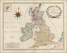
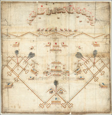
A very rare and important 'Lafreri School' map of Ireland.
This highly important map depicts all of Ireland, with its forests, rivers and mountains, all expressed through beautiful Italian Late Renaissance engraving. The overall shape of the island is quite progressive, and is markedly superior to well-known contemporary depictions, such as those by Abraham Ortelius (1570) and Gerard de Jode (1578). Rather than maintaining a potato shape, as shown on George Lilly's 1546 map of the British Isles, the southwest coast of the island (approximating County Kerry) correctly juts outwards. The map features numerous places (names familiar to the modern viewer), including Dublin, 'Droghda' (Drogheda) 'Wiclowe' (Wicklow), 'Kylcenni' (Kilkenny), 'Waxford' (Wexford), Waterford, 'Corck' (Cork), 'Lymryk' (Limerick) and 'Galwey' (Galway).
Interestingly, in spite of the island's overall accurate shape, certain places on Ireland's east coast, notably Dublin, Drogheda and Wicklow, are shown to be far to the south of their true locations. For instance Wexford (which is placed roughly accurately) is shown to be almost immediately to the south of Wicklow, when the two towns are actually 47 miles apart (a considerable distance for an island that is about 300 miles long at its maximum length).
Perhaps the most curious aspect of the map is the inclusion of 'Purgesoriu S. Patricij', ('St. Patrick's Purgatory'), located in a lake in the interior of the north of Ireland. According to a much beloved legend, during the 5th Century A.D., on an island in Lough Derg (County Donegal), St. Patrick, the patron saint of Ireland, was visited by Christ, who showed him a cave that was the entrance to Purgatory. The site, known as Station Island, was mentioned in texts as early as 1185 and became an important pilgrimage site in Medieval times. It appeared on maps during the early 15th Century and was the only Irish location noted on Martin Behaim's famous globe of 1492.
Although the present map was clearly made by a member of the 'Lafreri School' of cartographers, its authorship remains in question. That being said, evidence suggests that it was most likely made by Antonio Lafreri (1512-77, born Antoine du Pérac Lefréry in Besançon, Burgundy), one of the leading Italian mapmakers of the era. Lafreri settled in Rome in 1540, and by 1544 had opened his own engraving and print selling business on the Via del Perione. From 1553 to 1562, he formed a commercial alliance with the veteran dealer Antonio Salamanca. Following that time, he published on his own account. Lafreri was primarily a dealer and publisher, rather than an artisan in his own right. He carried a vast stock of maps and prints made by other printers from both Rome and Venice. He became known for producing IATO (Italian-Assembled-To-Order) atlases, each unique composite atlases featuring a selection of fine Italian maps, made to the tastes of individual clients. While the term was never used during this period, the Italian maps from this era are today often said to be of the 'Lafreri School'.
Claudio Duchetti (born in France as Claude Duchet, d. 1585) was the nephew of Lafreri. When his uncle died, Duchetti inherited many of his plates and published new editions of Lafreri's maps. Duchetti appears to have used the same plate from which the present map was printed to issue his Ireland map, featuring the imprint 'Romae Claudij Duchetti formis'. As Duchetti inherited many of his plates from his uncle, this strongly suggests that the present map (ie. the first state) was issued by Antonio Lafreri.
In turn, the present map is derived from Bolognino Zaltieri's Hibernia Insula non longe Brita[n]nia in Oceano sita est. (Venice, 1565), engraved by Paolo Forlani.
This map is a monument in the early mapping of Ireland, and is both finely engraved and intellectually curious. It is also very rare. We are aware of only 2 examples appearing at auction during the last 25 years and are not aware of another example appearing in dealers' catalogs during the same period.
![Northern Part of Ireland [with] Southern Part of Ireland](https://storage.googleapis.com/raremaps/img/small/88926.jpg)