|
||

|

|
|

|
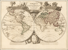
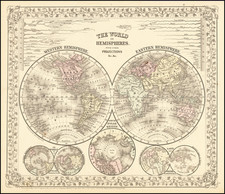
Striking example of this later edition of Mortier's double hemisphere map of the World, showing California as an island.
The 5 additional spheres illustrate night and day; the earth without water; the phases of the moon, and the eastern and western hemispheres. The American portion of the map is almost portolan style in its location of place names. The map is rich with cartographic misconceptions.
California is an island, there is a wonderful wide Northwest Pasage and Northeast Passage, the straits of Anian are shown, along with a strait of land coming from Asia in the Terra Iesso style. New Zealand is partially mapped, as is Australia. The Great Lakes are incomplete and Nova Zembla is an island.
Fine decorative map, which illustrated a number of 18th Century Dutch Bibles.
Pierre, or Pieter, Mortier (1661-1711) was a Dutch engraver, son of a French refugee. He was born in Leiden. In 1690 he was granted a privilege to publish French maps in Dutch lands. In 1693 he released the first and accompanying volume of the Neptune Francois. The third followed in 1700. His son, Cornelis (1699-1783), would partner with Johannes Covens I, creating one of the most important map publishing companies of the eighteenth century.
![[Early Fascimile of the Disputed Christopher Columbus Portolan Chart]](https://storage.googleapis.com/raremaps/img/small/66588.jpg)