|
||

|

|
|

|
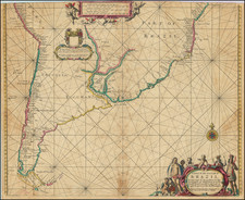
A fine example of the 1760 Rome edition of Juan Francisco D'Avila's rare map of the Jesuit Provinces, first issued in 1726, and then corrected and enlarged in 1732 by Antonio Marchoni and reissued in Novelle interessanti in proposite degli affari del Portogallo, published in Bern in 1732.
D'Avila's map of the Paraguay was the most complete and up to date map of the region drained by the Rio de la Plata and a significant improvement over earlier maps of the region. The map extends from Peru, Lake Chucuito and the source of the Rio de La Plata at Xareyes Lacas to the mouth of the Rio de la Plata, Buenos Ayres, Mendoza, etc. The map shows the central part of South America from the Atlantic Ocean to the Pacific Ocean, including most of Peru, Bolivia, Paraguay, Brazil, Uruguay, Argentina and Chile, with rivers and tributaries, tribes, territories and settlements. The map includes symbols indicating existing and destroyed Spanish towns and Jesuit missions.
This map is substantially improved from earlier maps of the region, including a more accurate depiction of the two bays at Montevideo, a corrected and more detailed image of the Parana Delta, and a vastly improved treatment of the various sources of the Rio Uruguay, etc. As noted in Maps of the Jesuit Mission in Spanish America, 18th Century,' Imago Mundi, Vol. 15, (1960), p. 117:
This map, as is well demonstrated by Furlong, was the work of Fratello Juan Francisco Davila or d'Avila (1682-1733), being published in Rome under the care of the Procurator, Fr. Girolamo Herran. "This map is without doubt the most complete and most comprehensive map undertaken by the Jesuits up to the middle of the eighteenth century" (Furlong, S.J., Cartografia jesuttica del Rio de la Plata, I (Buenos Aires, 1936) p. 44). In 1732, another edition, revised and amended (by Fr. [Antonio] Machoni ?), was issued; this was twice reproduced: in the Novelle interessanti in proposite degli affari del Portogallo .. (Berna, 1760), in volume I or II, depending on the copies; and in the 'Sammlung der Neuesten Schrifften welche die Jesuiten in Portugal betreffen,' II (Franckfurt, 1761) . . .
The John Carter Brown Library catalog entry (OCLC: 645200473) for the 1732 Machioni edition notes:
Marks routes used by the Jesuits and includes topographical notes on martyrdoms, etc. With dedication in elaborate cartouche at upper right, "Admodum R[everendo] In Ch[ris]to Patri suo P[atri] Francisco Retz Soc[ietatis] Jesu Praep. Generali XV. Hanc Terrarum Filiorum Suorum sudore et sanguin excultarum et rigatar[um] tabulam D. D. D. Provincia Paraquariæ Soc[ietatis] Jesu Anno 1732." . . . Also with 12 lines of Latin verse in decorative cartouche at center left; and key to conventional signs in cartouche at lower right. In its first edition of 1726, this map, anonymous except for the statement of dedication by the whole Province, is said by Streit to have been compiled by Fr. Antonio Maccioni (or, Machoni), a Sardinian who edited Pedro Lozano's Descripcion chorografica ... del Gran Chaco (Córdoba, 1733) and by Fr. Jerónimo de Herrán, who the same year edited Juan Patricio Fernández' Historica relatio ... (Augsburg, 1733). The above imprint is below the lower neat line. Expressed in a scale of "Leucæ communes Hispanicæ" in a cartouche at lower left. . . . References: Streit, III, no. 752; Furlong, Cartografía Jesuítica del Rio de la Plata, 23n.
It is one of the rarest and most important maps of the region, catalogued in several major South American collections as a source map for much of the regional cartography for the 18th Century.
The present edition of the map was produced in Rome by the eminent Jesuit cartographer Giovanni Petroschi (1715-66), a foremost authority on the geography of Latin America. He was likewise responsible for publishing other groundbreaking Jesuit maps such as Carolo Brentano's Provincia Quitensis (1751) and Jose Antonio de Sylverio Villaseñor y Sánchez 's map of Mexico (1754), considered to be the first modern map of New Spain.
Historical Context
The present edition of the map, issued in 1760, appeared at an especially critical time in the history of the Spanish Empire, the Jesuit Order, and South America in particular. As shown on the map, since the 17th Century, the Jesuits had constructed an archipelago of missions and outposts stretching through modern-day Paraguay, eastern Bolivia, northern Argentina and interior of southern Brazil. These settlements came to be known as the Jesuit Reductions (Reducciones Jesuiticas), which were set up to most effectively Christianize, tax, and govern the indigenous population, most notably the Tupi-Guarani peoples.
Over time, the Jesuits managed to create a society largely distinct from the coastal and mountain regions of South America, which were controlled directly by the Spanish and Portuguese crowns. An abundance of disciplined native labor and careful stewardship by the Jesuit friars created a thriving agrarian economy in the Reductions, providing the Jesuits with a massive income. The Jesuits armed and trained the Guaranis to form militias for the defense of the Reductions. While the Spanish and Portuguese crowns technically owned the territory, their officials had little or no influence on the region, which for all practical purposes functioned as an independent Jesuit state. Making matters even more interesting, many leading Jesuits in the Reductions, such as the Swiss Father Martin Schmid, were neither Spanish nor Portuguese subjects, and thus had no particular loyalty to either Iberian crown.
Importantly, the Guarani militias were increasingly coming into open conflict with the Spanish and Portuguese settlers in neighboring regions. In response, in 1754, the Portuguese expelled the Jesuits from their Brazilian Reductions.
Matters came to a head during the Guarani War of 1756, when a force of renegade Guarani militia fought a brief war against Spanish and Portuguese troops. While the Spanish and Portuguese decisively won the conflict, and while the Jesuits did not endorse or openly assist the Guarani rebellion, the Jesuits were blamed by both Madrid and Lisbon for having created the Guarani threat in the first place.
The Spanish Crown came to consider the Jesuit Reductions to be a grave security threat to their New World Empire. Moreover, following the Seven Years' War (1756-63), the cash-strapped Spanish Treasury came to covet the massive revenues generated by the Reductions. These circumstances dovetailed into the global event that came to be known as the Suppression of the Jesuits. For a variety of complex reasons that are beyond the scope of this catalog entry, the Jesuits had progressively lost favor with Europe's leading Catholic rulers. The Jesuit Order was entirely expelled from Portuguese territories in 1759. In 1767, Spanish King Charles III followed suit by banning the Jesuit Order and expelling all of its members from his empire. The Jesuit Reductions were thus completely dismantled by 1768, leaving a power vacuum that was only partially filled by the foundation of Franciscan missions. The area continued to be politically unstable throughout the 19th Century.
Importantly, the present 1760 edition of D'Avila's map was considered to be the authoritative map of the region during the Suppression era, and would most certainly have been the map of record used by Spanish officials as they oversaw the expulsion of the Jesuits.
While reduced sized copies of the map by Homann and Seutter appear on the market occasionally, OCLC lists 1 example of this large-format 1760 edition (John Carter Brown, which dates the map as 1760 but in the description, omits the last portion of the text below the neatline which states "Sumptibus Th. Dom. Gc. Anno 160 and may in fact be the 1752 edition, to which we have found references, but no confirmed examples of the map) and 1 example of the 1732 edition (Bibliotheque Nationale de Paris). We note also an uncolored example offered in Arkway Catalog 67 (2007), which is the example which we catalogued and sold in 2005.
Since the time of our first cataloguing this map, Loyola University of Chicago acquired a copy of the map.
![Carte Du Paraguay . . . [showing Rio Janeiro, Buenos Aires, Salta, etc]](https://storage.googleapis.com/raremaps/img/small/101636.jpg)

![[Magellan's Strait] Exquisita & magno aliquot mensium periculo Lustrata et iam retecta Freti Magellanici Facies . . .](https://storage.googleapis.com/raremaps/img/small/94451.jpg)