|
||

|

|
|

|
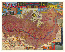
Official Government Land Office edition of this historicially map of the Cherokee Strip in Indian Territory, identifying the lands available for homestead claims during the Cherokee Strip Land Run of 1893.
The present map is the third edition of an extremely map dated September 4, 1893, privately printed by Wiggins (known in 1 example). A second privately printed edition, with the date of September 8th, 1893 is known in 3 examples and was the source for the present map which accompanied a US Congressional document entitled Letter From the Secretary of War . . 53d Cong., 1st Sess. House. Ex.Doc. No.27. and printed by the Government publishing office in on November , 1893.
As can be seen by comparing the titles, the present map post-dates by 4 days the first privately printed edition of the map. The other primary differences between the first edition of th map and the map which accompanied the Letter From the Secretary of War . . . is the extra table to the left of the Rock Island Railroad Promotional Table (which appears only on the first edition), entitled "How To Tell Your Section Corners," and gives a primer for determining the location of Sections, as offered by the Government and identified on the map.
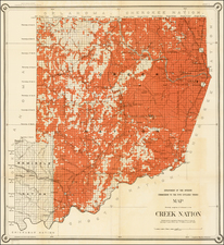
The Cherokee Outlet, more often referred to as the Cherokee Strip, was located in what is now the state of Oklahoma. It was a 58 x 225 mile strip of land south of the Oklahoma-Kansas border between the 96th and 100th meridians. The acutal Cherokee Strip was a two mile strip running along the northern border of much of the Cherokee Outlet and which was the result of a surveying error. In 1828 and 1835, the Government granted seven million acres to the Cherokee Nation. The Government guaranteed to the Cherokee that this land would be a perpetual outlet west for tribal hunting grounds. After the Civil War, because part of the Cherokee Nation had fought for the Confederacy, the government demanded a new treaty. They reduced the original reservation lands and permitted so-called "friendly tribes" to be moved into the eastern end of the Outlet.
With the start of the cattle drives following the Civil War, the Cherokee used their western land to make a profit. The cattlemen wanted to fatten their cattle on the rich grasses before taking them to railheads in Kansas so they leased land from the Cherokee. Settlers viewed the cattlemen's use of this area as a waste of fertile farmland and pressured the government to purchase the Cherokee land. Congress eventually paid $1.40 per acre for the land and announced the opening of the Outlet to homesteaders. President Grover Cleveland designated September 16, 1893, as the date for the run for the 6 million acres.
On September 16, 1893, 100,000 prospective settleers gathered for the land run into the Cherokee Outlet by horse, train, wagon, and even on foot, hoping to claim one of the over-40,000 quarter sections. At noon September 16, 1893, a shot rang out and more than 100,000 determined settlers raced for 42,000 claims. By sunset, farms were being established, and the cities of Enid, Perry, Alva, and Woodward had been populated. There were endless lines at federal land offices and more losers than winners.The Cherokee Strip Land Run was a tumultuous finale to what many have called the last American frontier.
The present edition is relatively scarce on the market, especially in such fine condition.