|
||

|

|
|

|
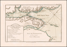
A scarce and highly detailed miniature map of the Siege of Louisbourg, illustrating the successful siege of the great French fortress by the British in 1758.
This finely-engraved map depicts the great fortress of Louisbourg, Cape Breton during the Seven Years' (or the French & Indian) War. Louisbourg was constructed at immense expense in 1720, and was charged with guarding the maritime approaches to the Gulf of St. Lawrence, and Quebec City beyond. As shown the city was built on a heavily-fortified peninsula beside a large natural harbour. While the British had previously taken the town in 1748, it was subsequently returned to France. In the summer of 1758 a large force under General James Wolfe besieged the town. Taking Louisbourg was seen as a necessary preresquisite to the ultimate British objective of attacking Quebec City. The map provides a fine overview of the town as it appeared during the operation. As noted on the map, the British finally took Louisbourg on July 26, 1758, and subsequently went on to take Quebec the following year. The battle was a pivotal event in the progress of the war.
This map was issued by Beaurain in 1765, both to serve as one of the border illustations added to his great wall map recording the events of the Seven Years' War, the Carte de Allemagne... (1765), and, as is the case here, as a separately-issued map, mounted on larger piece of paper and bound into a made-to-order atlas.
![[ French & Indian War Battle Plan--Louisbourg ]. Plan De Louisbourg...](https://storage.googleapis.com/raremaps/img/small/57192.jpg)