|
||

|

|
|

|
Extremely rare set of celestial maps, published in Mexico City by Francisco Jimenez in 1878.
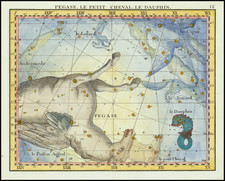
Francisco Jimenez's Carta Celeste Proyectada sobre el Horizonte de Mexico en Cuatro Planisferios que Indican la Posición de las Estrellas en los Dos Equinoccios y en los Dos Solsticios, is the result of a monumental effort by this distinguished Mexican geographer and the then Secretary of Development of Mexico, Vicente Riva Palacio, to produce the first Mexican celestial chart. Printed on the press of Hipolito Salazar (the patriarch of Mexican lithography), the chart consists of four planispheres (labeled I, II, III, and IV), which show the night skies as seen during the vernal and autumnal equinoxes and the summer and winter solstices at Mexico City's latitude of 19 degrees, 26 minutes North.
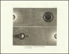
The planispheres are surrounded by various diagrams containing the latest astronomical information, such as relative distances of planets (in I), their volume, mass, and density with respect to Earth (in II), their relative diameters (in III), and their inclinations from the ecliptic (in IV). The clean and uncluttered view of the night sky on the charts is made possible by limiting the number of stars to 5th magnitude, including only the 88 constellations from the British catalog, drawing exclusively the curved constellation boundaries without images, and naming only the brightest stars. This scientific representation of astronomical information, paired with the beautiful tinted illustrations of the starry skies above Mexico City, reflect both the advanced level of astronomical science and of lithographic printing in Mexico in the late 19th century.
The printing of this celestial chart in 1878 coincides with the establishment, that same year, of the National Astronomic Observatory of Mexico in the balcony of the Chapultepec Castle. Interestingly, it was in this very same castle, where Francisco Jimenez, as a young soldier and engineer from the Heroic Military Academy of Mexico, surrendered and was taken prisoner by the American forces that invaded Mexico City thirty years before, in September 1847. He then went on to work alongside Jose Salazar Ilarregui on the establishment of the boundary line between the US and Mexico, eventually replacing Salazar Ilarregui as head of the Mexican Boundary Commission in 1857.
In 1861, Jimenez was commissioned along with Antonio Garcia Cubas to draw the Carta General de la Republica Mexicana, the first official map of Mexico, drawn and printed by Mexican geographers. This project was temporarily abandoned as a result of the French intervention in Mexico, but Garcia Cubas finally printed the map in 1863. Jimenez later participated in the Mexican scientific expedition to Yokohama, Japan to observe the transit of Venus in 1874. The results from this trip were quickly presented in Paris a few months later and published in 1875. Being one of the first countries to present the astronomical observations from the transit of Venus gave Mexican astronomers a much-deserved international recognition for their work. This significant accomplishment also paved the way in Mexico for the foundation of the National Astronomic Observatory in 1878 and consequently gave Jimenez the necessary funds and backing of the government to draw and publish the first Mexican celestial chart.
The second set of hemisphere can be seen here: /gallery/detail/36594
As noted at the center of the map, the map was intended to be accompanied by explanatory text by Faustino Navarro.
The maps and explanatory text are extremely rare. We locate no examples at auction or in dealer catalogues in the past 30 years. We locate only 1 example of the map in OCLC (National Library of Mexico) and 4 copies of the text.

![[Hydra]](https://storage.googleapis.com/raremaps/img/small/67628.jpg)