|
||

|

|
|

|
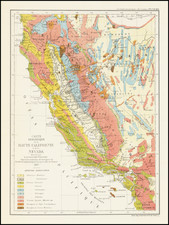
John Trask's map of the mineral districts of California is one of the most important early maps of the Gold Region, marking an important transition in the history of the gold regions between the initial boom years and the more serious long term commercial exploitation of the region.
John Trask's map of the mineral districts of California was the first truly detailed scientific survey of the region, undertaken by Trask, California's first State Geologist. By the time of Trask's Survey, the Gold Rush had spread considerably from the initial discoveries along the American River. Trask's map does a remarkable job of taking in the full extent of the mining boom at the height of its activity.
As noted by Thomas Streeter:
This is, to me, the most satisfactory of all the maps of the gold region. It is on a large scale--60 miles equals 8 cm. or about 3 1/8 in.---and hence is easy to read, though there is a vast amount of detail. East is at the top of the map, but one quickly adjusts to that orientation. My copy of his map for years hung in Henry Wagner's study at San Marino, California, and was much cherished by him. I acquired it from him in the fall of 1942.---TWS.
The map is also quite remarkable for its depiction of the early roads which traversed the region, vastly surpassing all earlier maps in detail and accuracy.
With the title repeated in both French and Spanish, it is clear that the map was intended for a wide distribution
The present example of the map was heavily annotated by an early owner and would seem to show various trade routes to San Francisco and the gold regions, as well as the route of several early railroads, including the Marysville & Benicia Railroad (incorporated 1851), and San Joaquin Railroad, neither of which ever came into operation. Notably, there does not seem to be any printed location for the route of the Sacramento Valley Railroad, organized on August 4, 1852, which would become the first operating railroad in California in 1856, under the direction of J. Mora Moss, whose name appears on the verso of this map (see below).
The offshore route traced in red includes a note showing trade lines, including the route to Santa Barbara (and return) and also shows transit to the Farallone Islands outside the mouth of San Francisco Bay (servicing the Guano Trade) and Drake's Bay. The same hand has added "N. Almaden" (New Almaden), "San Jose Mission", and "Union City", and traces the routes to the Gold Regions via the San Joaquin River and Sacramento River. There is also a route shown extending from Benicia to Napa, Sonoma, Petaluma and an unnamed Santa Rosa.
The Union City annotation helps to date the annotations, as the original Union City existed only from 1850 to 1854. The "original" Union City was founded in 1850 by John and William Horner, also called "Union City." In 1854, it merged with the nearby community of New Haven to form the town of Alvarado, named after the former Mexican governor, Juan Bautista Alvarado. The town did not return to the name Union City until 1959, when the towns of Alvarado, Decoto, and New Haven were merged to create a new city.
The annotations on the verso read:
Mandeville
Montgomery Block
Surveyor General's Office
????
J. Mora Moss at
Pioche Bayerque Co. (spelled phonetically)
Joseph Moss
Joseph Moravia (Mora) Moss was born in Philadelphia in 1809 and came to California during the Gold Rush. He was a partner in the banking firm of Pioche and Bayerque until 1859. J. Mora Moss was the first vice-president and the third president of the San Francisco Gas Co. (later to become P.G.& E.) and a trustee of the Sacramento Valley Railroad Co. in the early 1860s. In the late 1860s, his business interests expanded to include the California State Telegraph Co., Market Street Railroad and the Sitka Ice Industry. He was a Regent for the University of California and one of the directors of the School for the Deaf and Blind. On November 21, 1880, he died at his estate, Mosswood, in Oakland. was a financier and early regent of the University of California (1868-80).
One of Moss's earliest ventures in California involved a venture whereby he brought ice from Alaska to San Francisco. In 1851, he and a partner began importing ice from Novo Arkhangelsk. In 1853, Moss and Charles Baum created the American-Russian Commercial Company as a means of trading between California, Russia and England (most notably in ice, coal and furs), but also for providing general trade with the Russian Settlements in Alaska which had been cut off from their primary supply chains during the Crimean War by the British Navy. The enterprise included a number of San Francisco's leading businessmen and was an important part of the history pre-dating Seward's Folly, the purchase of Alaska from Russia in 1867. The enterprise would ultimately expand its trading routes to Central and South America.
Another of his early ventures included the New Almaden-Quicksilver Mining Company.
Mandeville would most likely be James W Mandeville (1824-1876), who came to California in 1849 as a miner. In 1852-1853, he served as a state representative for Tuolomne County and later as a state senator from 1854 to 1856. In 1857, he was appointed U.S. Surveyor General.
As noted above, the map is of the utmost rarity. We note only the Streeter copy appearing in auction records going back more than 50 years. Streeter obtained his copy from the well known collector Henry Wagner, whose copy hung in his library and was considered by Wagner one of his most prized possessions.
![[ Bringing Water To San Francisco ] General Map of the Spring Valley Water Works Hermann F.A. Schussler Chief Engineer. 1899](https://storage.googleapis.com/raremaps/img/small/98206.jpg)