|
||

|

|
|

|
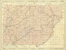
A rare large-format map of the important city of Tianjin, China, detailing the foreign concessions, printed in the city in 1912.
This large map is by far the finest and most detailed map of Tianjin made in the heady years surrounding the Chinese Revolution of 1911. With exacting detail, it shows all of the the city's streets, waterways, railways and major facilities (such as the 'Race Course', the epicenter of social activity for the city's Western population). Most interestingly, it shows the old Chinese city (the dark orange square in the center), the new city surrounding it, while lined along the river are the concessions of seven foreign powers. The map was printed in Tianjin by Chung-Tung Lithography works and the present edition was was clearly intended for a Chinese audience, as most of the typonymy is in Chinese characters, while certain major features are labelled in English.
Tinajin (called Tientsin by English speakers at the time) was one of the leading Chinese cities, considered the 'Gateway to Northern China'. It was strategically located on the Hai River, close to where the Grand Canal of China passed near the sea - the Bohai Gulf. In 1912, the city had a population of about 150,000 (today it has 14 million inhabitants!).
Following the Second Opium War (1856-60), the Chinese Emperor signed the Treaty of Tianjin (1860) which granted the British and the French rights to set up 'Concessions', or virtual sovereign trading enclaves, in major Chinese ports, including Tianjin. The French and the British quickly established their settlements, and over the following decades several other European powers followed suit.
Specifically, the map shows the following concessions (with the date of their establishment provided here):
- Britain (1860)
- Austro-Hungary (1901)
- France (1860)
- Germany (1899)
- Italy (1901)
- Japan (1898)
- Russia (1903)
The Belgian Concession (1902), located in the far south of the city, beyond the German Concession, is not shown.
While Tianjin boasted a large and lively expatriot scene and vast amounts of money were made by Western powers through foreign trade, towards the dawn of the 20th Century, the political situation was becoming increasingly unstable. The Western presence in Tianjin - and China in general - was beginning to resemble a tall 'House of Cards'.
In June 1900, 'The Boxers' (anti-Western Chinese rebels) gained control of much of Tianjin. After much fighting, the Eight-Nation Alliance (consisting of Russian, British, Japanese, German, French, American, Austro-Hungarian, and Italian forces) quickly retook the city. In the following years, the great Qing General Yuan Shikai led efforts to transform Tianjin into a modern city, establishing the first modern Chinese police force and setting up the first democratic municipal elections in China.
However, the Chinese Revolution of 1911, during which the Qing Dynasty was overthrown in favor of a republic, created uncertainty. World War I saw the removal of the German, Russian and Austro-Hungarian Concessions. The United States assumed a presence in Tianjin from 1920 (although they never formally acquired a Concession). While the 1920s and early 1930s were a swinging time in Tianjin, the Japanese invasion of China in 1937 hailed the end to the concessions. The British and French left in 1940, followed by the Americans in 1941. The Communist Revolution of 1949 removed the fixed foreign presence in Tianjin, and subsequently the city developed as a Chinese metropolis.
The map was issued in two editions, one with predominantly Chinese text (such as with the present example) and one with more extensive English toponymy. The map is rare, we can only locate 4 institutional examples of either edtion of the map (at the Library of Congress, the Bibliothèque nationale de France, the Columbia University Library and the Australian National Library) and we are not aware of another example appearing on the market in recent times.
The present map is a fascinating and unparelled record of one of China's most important cities, depicted during an especially momentious time in history.