The item illustrated and described below is sold, but we
have another example in stock. To view the example which
is currently being offered for sale, click the
"View Details" button below.


|
||

|

|
|

|
Stock# 35991
Description
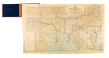
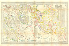
Interesting separately issued map of Iran, published in Tehran by A Sahab, one of the leading Iranian cartographic publishers.
The main map is the primary depicts the cities and regions of Iran, with the surrounding maps showing agricultural, Industrial, mineralogical, cultural and touristical information, map of major roads, map of major industries, map of tribes, map of major attractions, map of mines like oil, coal, etc.
Includes a table of city names and their distance from the capital as well as their elevations.
Fascinating map, from the golden age of the former Shah of Iran.