


|
||

|

|
|

|
A fine example of Nicolas Delamare's map of the Paris of Clovis I (beginning of the 6th-century AD), one of his ground-breaking series of eight maps illustrating the historical development of the French capital.
The present map is the second map of the series of eight, and depicts the Roman city of Lutecia (later renamed Paris), in the beginning of the 6th-century AD, shortly after it was conquered by Clovis I, the King of the Franks (466-511 AD). The Franks were a Germanic tribe, who following the Battle of Soissons (486 AD), conquered most of Northern France from the Romans. Clovis was the first Frankish king to convert the Christianity, and is generally thought to be the founding father of what would become the modern nation of France.
During the time of Clovis, Paris had a population of 30,000, a very large urban center in a Europe that was then almost entirely rural and agrarian. Clovis made it the captital of the Frankish kingdom in 508. The city was centered on the Ile de la Cite, and consisted of two main sections, both surrounded by walls. The section on the Ile itself and the portion occupying the area immediately adjacent on the Right Bank. On the Ile, the epicenter of life was the 'Place Publique', in front of the old Roman Forum, and just in the fore of the modern site of Notre Dame Cathedral. A bridge connected the island to the Right Bank, running through a large fortress. A key in the lower right identifies several locations, inclusing the several churches that were beneficiaries of Clovis' patronage. Of great curiosity, in the far upper left, is the labelling of the Roman Temple of Mars, on the site of today's Monmartre, its ruins having been identified by the antiquary Henri Sauval in 1657.
The present map is a rare separately published example of this map, which also appeared in the the first edition, first volume of Nicolas Delamare's La Traité de la Police (Paris, 4 vols., 1705-38), considered to be the most influential legal treatise produced in early modern France. It was the first detailed history of law enforcement ever published, and details the development of the subject throughout the history of Paris. In order to illustrate the size and nature of the city during different historical periods, Delamare painstakingly consulted a variety of published and archival sources in order to construct a series of eight maps that progressively depict the evolution of Paris from Roman times up to 1700. Delamare's maps are, in and of themselves, important, as they represnt the first time that anyone accomplished a systematic historical reconstruction of a city's development.
![[ Rare Imprint -- Theater of War in Europe ] Le Royaume de France divise en Toutes ses Provinces / Groot Toneel des Oorlogs, tusschen de Geallierrede Moghendhen en het Fransche Ryk -- Grand Theatre de la Guerre entre les Puissances Alliees et L'Empire Francois . . .](https://storage.googleapis.com/raremaps/img/small/104046.jpg)
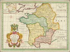
![[ France ] Galliae Regni Potentiss: Nova Descriptio Joanne Ioliveto Auctore . . .](https://storage.googleapis.com/raremaps/img/small/97834.jpg)