|
||

|

|
|

|
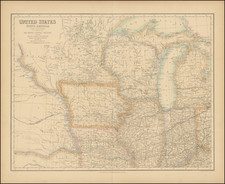
Detailed map of Minnesota, colored by counties. Shows towns, railroads, roads, lakes, rivers, trading posts, forts and other interesting features. Many of the counties in the North and West are still not present, including Kittson, Roseau, Marshall, Lake of the Woods, Koochiching, Hubbard, Norman, Red Lake, Pennington, Marshall, Clearwater, Lac Oui Parle, Yellow Medicine, Lincoln, Lyon, and Swift. Predates Manomin annexation by Anoka. Still shows Andy Johnson county, which would become Wilkin the following year.
Samuel Augustus Mitchell Jr. inherited the Mitchell Company from his father in 1860. For over thirty years, the company had specialized in the production of school atlases and wall maps of America. They were one of the pioneers on engraving on steel plates. In 1860, Samuel Jr. released the New General Atlas, which had been compiled in house and replaced a previous atlas by Tanner. The elder Mitchell died in 1868 and Samuel Jr. continued the business until the 1890s. At its height, the Mitchell Company employed 250 people and sold 400,000 publications annually.