|
||

|

|
|

|
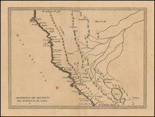
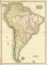
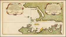
Finely executed manuscript chart of the West Coast of South America, between the area just north of Lima and Cape Horn, possibly prepared for use at sea during the second expediton of Domingo Boenechea aboard the Aguila on behalf of the Spanish Viceroy of Peru.
The chart identifies two separate expeditions between Lima and Cape Horn, one passing through the Straits of Magellan (red pencil) and passing south of the Strait (black pencil). The chart also shows an amendment in a different hand, locating the Rio Machacoma, south of LIma. The map also contains and navigational note concerning the navigation around Ysla de los Estados (Staaten Island). The chart has also been carefully extended, likely during the voyage, to allow for the written recording of the transit of the Voyage further to the south than the original chart allowed.
The map title goes on to state that the chart was:
Copiada para uso del Capitan se Navio Dn. Joseph de la Somaglia Comte del Navio Peruano. En el Puerto dela Concepcion de Chile y Maio de 1774 Por Joseph Camacho.
It is believed that the Island of Tahiti may have been first discovered either by Juan Fernandez in 1576-77 or by Pedro Fernandes de Queiros on February 10, 1606. However, the first European to visit Tahiti was Lieutenant Samuel Wallis aboard the HMS Dolphin in June 1767, followed by Louis-Antoine de Bouganville in April 1768. In July 1769, Captain James Cook arrived in Tahiti to observe the Transit of the Venus across the sun for the Royal Astronomical Society.
Following these early contacts, the Viceroy of Peru, Manuel de Amat y Juniet organized an expedition to settle and colonize Tahiti in 1772. Don Domingo Boenechea sailed from Callao, Peru on September 26, 1772, on the frigate Aguila to establish a colony on Tahiti, which the Spaniards named Amat after the Viceroy. On sailing through the Tuamotu Archipelago, Boenechea discovered an island on October 28 which he named San Simon y Judas (Tauere), and on October 31, another which he named San Quintin (Haraiki). On November 1 he encountered Anaa, which he named Todos Santos; and on November 6 he sighted Meetia, which received the name of San Cristobal. On November 8 he arrived at Tahiti, which he named Amat. After making a survey, he sailed for Moorea, to which he gave the extra name of Santo Domingo. On his return, he sighted the coast of Chile on January 21, 1773; but his report was dated March 8, 1773, in the port of Valparaiso.
After his return and report to Viceroy Amat, Boenechea was ordered to make a second voyage aboard the Aguila, accompanied by the Jupiter, with lieutenant Don Thomas Gayangos as second in command. Boenechea left Callao on September 20, 1774, taking with them two priests, who would establish a Catholic Mission and colony on Tahiti. On October 29 they sighted an island which was named San, Narciso (Tatakoto), and two days later, the island of San Simon (Tauere). On November 1 two islands were sighted which were named Los Martires (Tekokoto) and San Juan (Hikueru). The island of San Quintin (Haraiki) was seen, and at Todos Santos (Anaa) they traded with the natives for coconuts and artifacts. On November 13 they sighted San Cristobal (Meetia), and the next day Amat (Tahiti). After some exploration of the coast, they anchored on November 27 in a harbor which they named Santa Cruz de Ohatutira in the Tautira district of the island. They met with the local chief, Vehiatua, and land was selected for the homestead and the house built for the priests.
After settling the priests, Boenechea sailed. northwest for Orayatea (Raiatea). He passed Tetiaroa, which he renamed Los Tres Ermanos (Hermanos); sighted Huahine, which he named La Hermosa; and saw Raiatea, which he named La Princessa. Maurua was renamed San Antonio, and Borabora received the new name of San Pedro. The ships returned to Tahiti, where Boenechea died on January 26, 1775. Gayangos thereafter discovered the island of Raivavae in the Austral group which he named Santa Rosa, before returning to Callao on April 8, 1775.
The Aguila was next sent on a third voyage, under the command of Don Cayetano de Langara, to carry supplies to the priests at Tahiti, sailing from Callao on September 27, 1775 and arriving at Amat (Tahiti) on October 30, 1775. The Aguila anchored at the harbor of Santa Cruz de Ohatutira and found that two priests, Father Geronimo Clota and Father Narciso Gonzalez, who had been landed on the previous voyage, had not been able to establish a mission and had suffered from lack of protection. Langara took the priests on board and sailed on November 12, 1776, ending the Spanish attempt at colonization of Tahiti.