


|
||

|

|
|

|
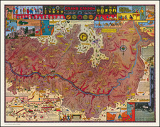
Fine example of this later edition of Captain Marcy's monumental map, referred to by Carl Wheat as "one of the best of the period".
This is a most informative map of the region illustrating the explorations of Capt. Marcy, with inputs from Colonel Emory's Boundary Survey, Capt. Sitgreaves' map, as well as those of A.B. Gray and J. de Cordova.
The map details the area from the Mississippi River to the Colorado, and from about 30° N. latitude to the Arkansas River. North of the Gila River the region is noted as Unexplored, with a legend reading, "In the vicinity of this place a tract of country is found which is said by several trappers to be exceedingly fertile, and abundantly timbered and well watered." This erroneous note (in the Sonora Desert) shows up a decade later on A.J. Johnson's early maps of the Southwest. Filled with a copious amount of important information and detail on Oklahoma, North Texas, New Mexico and Arizona, the map locates exploration routes, Indian tribes, disputed territories, and much, much more.

![[Manuscript Map and Grant Translation for Adolphe Sterne's Lands in Tyler County, Texas] Translation of Title to One League of Land to Adolfo Sterne [Tyler County, Texas land grant]](https://storage.googleapis.com/raremaps/img/small/85549.jpg)