|
||

|

|
|

|
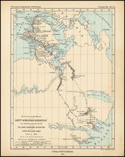
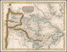
Historically important annotated example of a very rare large-scale map of Southeastern Vancouver Island, which includes early manuscript additions depicting the southern section of the route of the Esquimalt & Nanaimo Railway, the construction of which was one of the key events in the history of the island.
This fine wall map, printed in 1880, was then the definitive survey of the region. Focused on Victoria, it extends west to include Sooke, as far north as Chemainus, as well as embracing the Gulf Islands of Salt Spring, Mayne, Pender and southern Galiano Island. The only urban area, the City of Victoria, barely extends beyond the inner harbor, while the surrounding township is shown to still be largely rural, save for some development around The Gorge. To the west, the dockyard at Esquimalt is shown, which since 1865, had been the headquarters of the West Pacific Fleet of the British Royal Navy. There was then very little settlement beyond the immediate Victoria-Esquimalt area, although crude roads extended northwards, up the length of the Saanich Peninsula, up the east coast of the island, and westward to Sooke Harbour.
The map was issued by the Government of British Columbia, under the supervision of William Sinclair Gore, the provincial Surveyor-General, acting under the orders of Premier George Anthony Walkem, who simultaneously served as B.C.'s Chief Commissioner of Lands & Works. Owing to the technical challenges of lithographing such a large map, the original manuscript map was sent away by the publishers M.W. Waitt & Co. to be printed by Britton & Rey in San Francisco. The map is based on exacting scientific surveys, with the delineation of the shorelines predicated on hydrographic charts first issued by the British Admiralty in the 1850s, and since continually updated. The terrestrial surveys were conducted by Crown surveyors who employed the latest trigonometric techniques to organized the area into named townships, which were further divided into numbered lots in preparation for them to be auctioned off to private buyers.
This present example of the map is of added historical importance, having been augmented by manuscript additions depicting the route of the southern section of the Esquimalt & Nanaimo Railway, the construction of which was one of the seminal events in the history of Vancouver Island. The central interior of Vancouver Island, located to the northwest of the area depicted on the map, had long been known to include large coal deposits. The main markets for the coal were the bustling port of San Francisco and the Royal Navy's base at Esquimalt. While the coal could be shipped out of the port of Nanaimo, it was recognized that the creation of a railway connecting Nanaimo and the coalfields to Esquimalt would greatly lower the costs of transporting the coal to market.
In 1882, James Dunsmuir, the 'Nanaimo Coal Baron', who owned most of the best coal deposits, lobbied the federal government to be given the concession to build the railway. Upon gaining the rights, he formed the Esquimalt & Nanaimo Railway Company in partnership with Leland Stanford, Charles Crocker and Collis P. Huntington (three of the 'Big Four' California Railway barons). As the project, once completed, promised to energize the province's economy and open vast areas of Vancouver Island to development, the British Columbia government granted the E & N Railway Company exceedingly favorable inducements, including $750,000 in cash and rights to almost 20% of Vancouver Island's landmass.
However, the project was soon caught up in controversy. Dunsmuir, who was also a government Member of the British Columbia Legislature (serving under Premier Walkem), was accused of abusing his office to gain such a generous deal from the Province. Moreover, the E & N Railway lost a high-profile court case, in which it was ruled that settlers could not be summarily removed from their land plots to make way for the railway. Consequently, the company had to pay significant sums to individuals whose lands were located in the way of the intended route of the railway.
Nevertheless, construction, which began in the early months of 1883, proceeded working in both directions, moving south from Nanaimo and working north from Esquimalt. Depicted on the map in manuscript by a red line, is the southern section of the railway running from Esquimalt up to the Shawnigan Lake area. It was likely added to the map at some point in 1885 or 1886, when the route for this section had been finalized, but before the project had been completed. The 'golden spike' which hailed the completion of the railway, was laid on August 13, 1886, at Cliffside, not far from where the red manuscript line on the map leaves off.
The present example of the map, mounted on linen with a loop intended for a roller, was clearly hung on a wall and consulted by individuals with a keen interest in the E & N Railway, perhaps Dunsmuir and his associates, land speculators or officials concerned with the related court case. In all, the map, with its manuscript additions, is an important artifact that had a role in one of the key events in the history of Vancouver Island.
This map is very rare. We are aware of no other examples appearing at auction or in dealer's catalogs in the last 25 years and can find only one example in institutional collections (U.K. National Archives: War Office Records). In spite of the map's importance, its low survival rate can be accounted for by the fact that copies would have been subject to heavy use as practical aids.