|
||

|

|
|

|
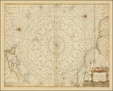
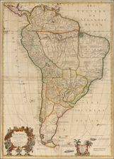
The First Printed Sea Chart of the Continent of South America
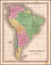
John Seller's sea chart of South America is a great rarity, and holds the distinction of being the earliest chart of the continent of South America to be printed in England. It would also appear to be the first printed Sea Chart of the whole of South America. Unlike earlier sea charts of South America, such as Arnold Colom's Zuyder Deel van America (1658), which leaves out the northern part of the Continent, Seller depicts the entire continent as a whole, and in a visually appealing way, resting it on its side (in the manner of Jan van Linschoten). The map is very finely engraved, and is adorned with an attractive title cartouche of auricular decoration, flanked by native peoples, with two compass roses and sailing ships inhabit the seas.
The present chart is extraordinary in that the overall shape of the continent is depicted in a manner far more accurate and advanced than shown on other contemporary printed charts. The exaggerated bulbous shape that had long been favored by cartographers is no longer present. Seller clearly had access to the finest available printed regional charts of the continent, and clearly exercised great skill and discretion in choosing how to integrate this varied geographic intelligence. His depiction of the coastlines of Brazil is especially fine, derived from the latest Dutch sea charts, such as Pieter Goos' Paskaart van Brasil (1666). Even more interestingly, is Seller's depiction of the far southern regions, which shows that he had access to the late-breaking manuscript maps of Rear-Admiral John Narborough, following his expedition to Argentina and the Straits of Magellan in 1669-71.
John Seller (1630-1697) was a towering figure of English cartography and key pioneer of modern mapmaking in variety of disciplines. In the early 1670s, he set about to break the near-monopoly enjoyed by the Dutch in sea chart publication. His production of the Atlas Maritimus or a Book of Charts Describeing the Sea Coasts . . . of the World (1675), marked a watershed moment in the development of hydrography in Britain. He concurrently worked on the first parts of The English Pilot, including the charts of the Northern and Southern navigation, however financial constraints prevented him from completing the project. This endeavor was subsequently taken up by John Thornton, and later the firm of Mount & Page, who resolutely gave London a leading place in the sea chart trade.
Seller's chart of South America is very rare, as it is thought that it was pulled from production in favor of regional maps of the continent. We have located only a single reference to this sea chart, bound into a copy of Seller's Atlas Maritimus, in the collection of the Maritime Museum in Rotterdam. We note also a separate copy in the collection of the Clements Library and a copy in the British Library. The chart exists in a later edition, published by Jeremiah Seller and Charles Price ( circa 1703).
John Seller was one of the most notable map and instrument makers in England in the late-seventeenth century. He was especially known for the sea charts, many of which featured in his influential English Pilot and Atlas Maritimus. Seller was born in London in 1632. His father was a cordwainer and John was apprenticed to Edward Lowe, of the Merchant Taylors’ Company. He was made free of that company in 1654. Later, he also was made a brother of the Clockmakers’ Company, which housed several instrument makers. He started business as a compass maker but expanded his offering to include navigational instruments and charts.
Seller’s career was halted temporarily, and fantastically, when he was tried for high treason in 1662. He was accused of involvement in a plot led by Thomas Tonge. While Seller likely only unwisely repeated rumors, he was convicted. The other conspirators, who did admit some degree of guilt, were executed, but Seller maintained his innocence and, via insistent petitions, he eventually secured his release from Newgate Prison.
This episode did not seem to slow Seller’s rise too much, however. Seller was granted a royal license to publish English-language maritime atlases. This gave him a near-monopoly and led to his being named hydrographer to the King in 1671. Although the point of the project was to produce English charts of Dutch dominance and bias, Seller ended up using many Dutch plates as his base material. The first volume of The English Pilot was published in 1671, followed by more volumes as well as The Coating Pilot (1672) and the Atlas Maritimus (1675). Seller was commercially successful, but some of his projects required further support. The English Pilot was eventually taken over by John Thornton and William Fisher, for example, and his proposed English atlas only produced maps of six counties.
Seller’s sons, John and Jeremiah, followed in their father’s profession. Seller also apprenticed several promising young men, including Charles Price, with whom his sons partnered. Through Price, Seller can be seen as the founding figure of an important group of London mapmakers that included Price, John Senex, Emanuel Bowen, Thomas Kitchin, and Thomas Jefferys.