|
||

|

|
|

|
A Pair of Highly Important and Rare Maps of Korea, from the groundbreaking work of Phillip Franz von Siebold
The present maps are from Phillip Franz von Siebold's study of Korea, the final volume of his epic work Nippon. Archiv zur Beschreibung von Japan und dessen Neben- und Schutzländern: jezo mit den südlichen Kurilen, Krafto, Koorai und den Liukiu-Inseln (7 volumes, printed in Leiden, Netherlands, 1832-1852). Highly detailed and profusely illustrated, it was by far the finest and most important European study of the history, ethnography, geography and flora and fauna of Japan and Korea published to date. More than any other work, it showcased Japan and Korea to Western intelligentsia, on the eve of the wholesale opening of these countries to European trade and exchange.
Phillip Franz von Siebold (1796-1866) was a German physician, who joined the service of the Dutch East India Company (the VOC). Arriving in Japan in 1823, he quickly made contact with the country's leading scholars, as well as many senior political officials, and steadily acquired an unprecedented collection of botanical and ethnographic specimens. While Japan, ruled by the military regime of the Tokugawa Shogunate, had long permitted the Dutch to trade out of the southern port of Nagasaki, the country was still largely closed to Westerners, and remained something of an enigma. Even more mysterious was Korea, where the ruling Joseon Dynasty pursued a policy that had kept the peninsula almost entirely isolated from foreign contact, save for the kingdom's tributary relationship with China. While Siebold was never able to visit Korea, he gained valuable intelligence from Chinese merchants, as well as Korean sailors who visited Nagasaki after being stranded on the Japanese coasts.
Sielbold's intense intellectual curiosity led him to search for the most advanced cartography of Japan and Korea. While on a visit to Edo (modern Tokyo) in 1826, he befriended Takahashi Kageyasu, the Japanese court astronomer, who provided him with a series of sophisticated maps, many of which were by the late Ino Tadataka (1745-1818). Tadataka famously conducted the first modern mapping of Japan, as well as compiling maps of Korea from the latest sources.
Curiously, it was Siebold's possession of these fabulous maps that led to the so-called "Siebold Incident", which resulted in his expulsion from Japan. While the Japanese authorities seemed tolerant, if not a little bemused, by Siebold's endeavors to collect natural specimens, this indulgence had its limitations. In 1829, when officials accidentally discovered Siebold's map collection, they were aghast that a foreigner possessed sources that contained such accurate and detailed geographical intelligence and military information. Accusing him of being a Russian spy, they placed him under house arrest, before expelling him from the country. Surprisingly, the Japanese authorities did not confiscate all of Siebold's maps, and it is more than likely that the originals on which both of the present maps are based were part of this politically charged collection.
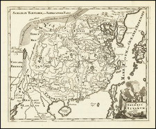
The Karte von der Koraischen Halbinsel is of considerable historical importance as it is by far the most detailed contemporary map of the Korean Peninsula. While not based on precise trigonometric surveys, the map possesses an overall planimetric accuracy, especially when compared to other maps produced up to the period. While the title is in German, the nomenclature on the map phonetically expresses Korean names in Western text. As stated in the title, it is predicated on a Japanese original, almost certainly a manuscript drafted by Tadataka, which in turn, was likely based on very recent Chinese sources. The level of detail is simply astonishing, and as noted on the legend, symbols identify numerous key attributes. These include the locations of 'First, 'Second' and 'Third' tier cities and villages; military encampments and depots; naval bases; as well as naval and army sentry points located across the peninsula. It is also a highly detailed transportation map, as it features a comprehensive web of road systems, while listing the distances between key points. The map is unquestionably a highly advanced military map of Korea, and was considered to be of the greatest value and sensitivity by Japanese officials who had long harbored concerns with respect to the peninsula.
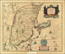
The second map, Koorai, although titled in both Dutch and German, features Chinese characters, and while not as detailed as its partner, it is nevertheless a faithful record of what was an important Chinese manuscript map of Korea, dating from around 1800. The original map likely came into Tadataka's possession by way of Chinese traders, and possesses the highly attractive pictographic quality that was long the signature of East Asian cartography. In essence, as related by the legend beneath the title, the map identifies all of the major cites and settlements throughout the peninsula, distinguished by nine levels of symbols. Seoul which, since 1394, had been the capital of Korea, is prominently distinguished by being bracketed by four squared corners. Far to the north, along the Chinese border, appears Baekdu Mountain, the 9,000 foot volcano which is the highest peak in Korea. Interestingly, while the four compass points marked on the map are identified by Korean characters, the rest of the map features Chinese characters.
Upon Siebold's return to Europe in 1830, he settled in the Dutch university town of Leiden. He soon opened a magnificent museum for his specimen collection, and set to work on his monumental publication Nippon, a project that would last 20 years. Siebold evidently drafted the Karte von der Koraischen Halbinsel in 1840, although it was first published, along with the Koorai map, in 1852.
Siebold's maps were published at a very critical time in the history of Korea and its relationship with the Western powers. While the Joseon Dynasty had, thus far, almost entirely succeeded in ensuring that Korea avoided direct contact with the West, circumstances would rapidly change. In 1853, the American gunboat, the USS South America, visited Pusan. In the years to follow, the peninsula would be the focus of Christian missionaries and French and American military interventions, exacerbating tensions that occasionally resulted in armed conflict. In the 1870s, the Joseon Dynasty formally abandoned its policy of isolationism, signing treaties with Japan (1876) and the United States (1882). Importantly, Siebold's Karte von der Koraischen Halbinsel would have been viewed by Westerners as the authoritative and most highly detailed map of Korea during this critical transitional period.
Both Siebold's
Karte von der Koraischen Halbinsel and the
Koorai map are extremely rare; we are not aware of either of these works appearing as separate maps on the market during the last 30 years. For example, in 2013, Donald Heald, was offering an incomplete set of the books for $100,000 which was lacking more than 500 pages of text and over 30 plates

![Asie . . . 1650 [with unusual depiction of the West Coast of North America and the Island of Corey]](https://storage.googleapis.com/raremaps/img/small/102556.jpg)