This item has been sold, but you can enter your email address to be notified if another example becomes available.


|
||

|

|
|

|
Stock# 34257
Description
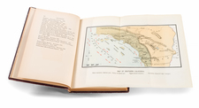
Detailed map of the American River from the foothills of the gold region to he Sacramento River, showing Sutter's fort and an number of mines.
The map Accompanied the Message of the President announcing the discovery of Gold in California. making it one of the earliest obtainable maps of the gold regions.
The map covers the country along the American River from its junction with the Sacramento River to just above Weber's Creek, showing Sutter's Fort and numerous other diggings. Lt. William T. Sherman, of later Civil War fame, drew the map when he was adjutant to U.S. Military Gov. Mason. A most desirable Gold Rush map.
Condition Description
Minor foxing and toning along several folds.
![[Nevada and parts of California, Utah and Arizona] Explorations and Surveys South of Central Pacific R.R. . . . Preliminary Topographical Map Map Embracing in Skeleton a Portion Only of the Notes from Surveys . . . 1871 (with original text)](https://storage.googleapis.com/raremaps/img/small/82964.jpg)