|
||

|

|
|

|
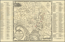
The Earliest Obtainable Version of the Bonner Plan of Boston.
Fine example of George Louis Le Rouge's 1755 plan of Boston, issued at the beginning of the French & Indian War in his Recueil des plans de l'Amerique septentrionale.
Le Rouge's plan is the first reduced version of John Bonner's New Plan of ye Great Town of BOSTON in New England of 1722, the first printed plan of the city.
This map provides a complete street plan of the town, and an alphanumeric legend indicates the twelve wards as well as twelve places of worship. The town's defenses are indicated, Long Wharf is clearly delineated, and in the area of the Common one can make out the Mall, Powder House, and the tower on Beacon Hill.
Along the lower part of the town, there are two batteries marked with British Flags.
Le Rouge's plan is based on state 7 of the famous Bonner plan (1743), in which Hollis and Pleasant Streets have been added to the southeast of Boston Common. It was issued in Le Rouge's Recueil des Plans de L'Amerique Septentrionale (1755), a rather rare atlas of American town plans issued just before the onset of the French and Indian War.
George-Louis Le Rouge (1712-1790), though known for his work in Paris, was originally born Georg Ludwig of Hanover, Germany. He grew up and was educated in Hanover, after which he became a surveyor and military engineer. Around 1740, however, Le Rouge moved to Paris and set up shop as an engraver and publisher on the Rue des Grands Augustins. It was at this time that he changed his name, adopting a French pseudonym that would later become quite famous.
Le Rouge spent much of his forty-year career translating various works from English to French, and his cartographic influence often came from English maps. His experience as a surveyor and engineer in Germany made him a skilled and prolific cartographer, and he produced thousands of charts, maps, atlases, and plans. His work spans from garden views and small-town plans to huge, multiple-continent maps. Le Rouge eventually accepted the position of Geographical Engineer for Louid XV, the King of France.
Later in life, Le Rouge became well-known for publishing North American maps, such as in his Atlas ameriquain septentrional of 1778. One of Le Rouge’s other more famous works is the Franklin/Folger chart of the Gulf Stream, which he worked on with Benjamin Franklin. Franklin and Le Rouge corresponded around 1780 and collaborated to create this map, a French version of Franklin’s famous chart which was originally printed in 1769.
![[ Revolutionary War Boston ] Carte Particuliere Du Havre De Boston . . . 1780](https://storage.googleapis.com/raremaps/img/small/61227.jpg)