


|
||

|

|
|

|
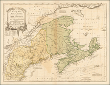
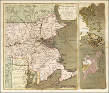
Important early broadside map of the Theater of War in New England, which includes Washington's march through Lexington & Concord and a Plan of the Battle of Bunker Hill, published by Sayer & Bennett in London in 1775.
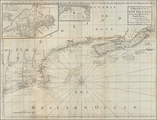
Sayer & Bennett's map of the Seat of War is one of the two earliest pictorial accounts of the Battle of Bunker Hill, preceded only by Jeffeys & Faden's A Sketch of the Action between British Forces and the American Provincials on the Heights of the Peninsula of Charlestown, which provides only a small simplistic model of the troop movements and placements around the battle site. Prepared to inform the British public of the totality of the Theater of War and the British Victory, Sayer & Bennett's work is without question the best pictorial account of conflict.
Believed to have been based upon a letter from a June 25, 1775 letter from General Burgoyne to Lord Stanley (which Sayer & Bennett later published separately as a broadside), the map provides a dramatic account of the Battle, including an inset showing Charlestown under attack by British forces, with the town in flames as British warships bombard it from the water, and a British battery shelling the town from across the Charles River.
The map is credited to "an American volunteer," and it is among the most accurate maps of the period from an American perspective. The movement of colonial troops to Boston, including Washington's army (through Lexington & Concord), the New Hampshire Rangers and a Connecticut Militia from the South, is outlined on the principal map with minute figures of troops, horses, and cannon. The vivid inset battle-plan of the action at Bunker Hill, based on John Norman's iconic engraving of the battle, shows Charlestown in flames.
This map would have been of tremendous interest to the British public, which was then just receiving the earliest accounts of the American Revolution.
The map is very rare on the market, with only 1 recorded auction appearance in the past 30 years.
Sayer & Bennett refers to the partnership of Robert Sayer (ca. 1724-1794) and John Bennett (fl. 1760-d.1787), which lasted between 1774 and 1783. Bennett had been Sayer’s apprentice. The pair specialized in American atlases, based on the work of Thomas Jefferys, who plates had been acquired by Sayer when Jefferys went bankrupt in 1766. They also began publishing navigational charts in the 1780s and quickly became the largest supplier of British charts in the trade. However, in 1783 Bennett lost control of his mental faculties and the partnership dissolved as a result. Sayer’s business was later passed to his employees, Robert Laurie and James Whittle.