


|
||

|

|
|

|
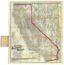
Important map of Baja California, prepared for J. Ross Browne and the Lower California Company in 1868.
The map is without question the finest and most detailed geographical and commercial mapping of Baja California, representing the first modern depiction of the Peninsula and providing the first graphical depiction of its interior and commercial prospects, including the potential for yet to be exploited harbors, internal lines of communication and other features. The map comes on the heals of Antonio Garcia Cubas map of the Baja Peninsula, published in 1858, the first Mexican published map of Baja California. Browne's map, shows for the first time the many internal roads within Baja California and improves upon the geographical representation, also identifying for the first time the various Municipalities. The map omits the topographical details included by Garcia Cubas, but most otherwise be viewed as a superior production. especially in the north, where the Bays of San Quentin, San Felipe (not shown at all by Garcia Cubas), Bahia de Los Angeles and other bays on both sides of the Peninsula are treated with much greater care.
Browne's map was produced at a time when Americans were actively flowing into Baja California from California, Arizona and by sea, in order to pursue the recent mineral discoveries in Sonora and the northern part of Baja California. As a result of this mineral boom and Mexico's desire to encourage settlement by granting floating colonial grants of vast tracks of land to companies willing to promote settlement in the region, a number of commercial ventures were formed in order to exploit these opportunities.
The prospect of colonizing Baja California began in earnest shortly after the discovery of Gold in 1849. Perhaps the most noteworthy of these attempts was undertaken by William Walker, a San Francisco Lawyer and serial fillibuster. In June 1853, Walker, a pro-slavery advocate, applied to the Mexican Government for a colonial grant, which was declined. Walker thereafter recruited a group of supporters of slavery and the Manifest Destiny Doctrine (mostly from Kentucky and Tennessee), to establishing an independent republic in Mexico, which might ultimately become as slave holding state in the United States, in the same fashion as the Republic of Texas. Walker and his supporters conquered La Paz, capital of Baja California, then set up as the President of the Republic of Baja California, with his capital in Ensenada. His efforts to take Sonora (and create the Republic of Sonora) failed and he was forced out of Mexico and tried in the US for conducting an illegal war under the Neutrality Act of 1794, but was later acquited, as a result of his popularity. He would later conduct a similar (and briefly successful) fillibuster in Nicaragua in 1856, before his attempts to take over Honduras resulted in his execution in 1860.
The second major effort to colonize Baja California was undertaken by the Lower California Company. The Company was formed to take over a land grant contract originally negotiated in 1864 by Jacob P. Leese, in order to exploit the mineral resources of Baja California. The company enlisted John Ross Browne and a group of scientists on a mission to survey Baja California. Browne, already an accomplished writer, moved to California in 1849, where he served in a number of government positions, including agent for the Treasury Department, surveyor of customs houses and mints, investigator of Indian and Land Office affairs, and official reporter for the state constitutional convention. In 1868, he was appointed US Minister to China. The report from the scientists was largely unfavorable and the Lower California Company ultimately had its grant rescinded by the Mexican Government in 1871, for failure to attract sufficient settlers to the region.
Between 1880 and 1888, a large number of similar concessions were granted. The largest of these was to Louis Hüller, granted in 1884, and comprised 5.5 million hectares. This venture lasted until 1917. Another concession, of 700,000 hectares, granted to Adolf Bülle in 1884, was rescinded in the same year. A third, comprising 1.4 million hectares, was granted to Flores, Hale & Co. This grant, rescinded in 1917, was revalidated in 1921, but the company went bankrupt in 1926. Still another concession, of 500,000 hectares, was granted in 1885 to Pablo Macedo who started mining operations with French capital. This operation lasted until 1954.
Of all the ventures, the Lower California Company's efforts are the most interesting and, because of the involvement of J. Ross Browne, resulted in several excellent promotional pamphlets. The intentions of the Lower California Company are illustrated by the following introductory paragraphs of one of Browne's promotional pamphlets, entitled Lower California: Its Geography and Characteristics . . . (1868), promoting the colonization of Baja California by Americans:
It is the object of this pamphlet to call attention to that remarkable portion of the Pacific coast which adjoins the United States upon its south-western border, and which is known to the world as the peninsula of Lower California. It is also its object to inform the public that the bulk of that peninsula, including its harbors, fisheries, and mines, has been acquired, under concession or grant from the Mexican Government, by certain American citizens, who have organized themselves in New York, under the title of the Lower California Company. And it is, finally its object, after a brief glance at the geographical position and natural capacities of the peninsula, to explain the character of that grant, and the powers and purposes of the Company . . .
The geographical importance of Lower California will at once be seen by reference to the map. Springing boldly from the main land at 32 ° North latitude, it juts downward into the Pacific to the distance of six hundred miles, with an outer and inner line of lofty coast, abounding in grand harbors, and sentinelled by numerous islands. It constitutes, therefore, a natural fortress of incalculable strength, which on its outer face domineers the vast commerce of the North-west coast, while its inner shore and islands overawe the richest part of Northern Mexico. This eastern shore, moreover, presides over that famous arm of the sea known as the Gulf of California; at the head of which comes in the mouth of that great river (Colorado) whose waters, rising far north in the interior of Utah, offer hundreds of miles of steam navigation to the internal trade of the United States, with a westward outlet for it to the sea. It would, therefore, be hardly possible to compass, much less to over-estimate, the geographical importance of Lower California to the western portion of the continent. In this point of view it has long been an object of great interest to those who have speculated upon the future destiny of North America; and the source, as well, for the last twenty years, of deep regret that it was not acquired by the United States Commissioners, at the time of the acquisition of Upper California, of which it is the natural appendage. The development of the precious metals along the whole line of the Pacific coast, the eager spring in that direction of trans-continental railways to meet the coming commerce of the East, and the still more marvellous indications (through the Chinese treaty, and otherwise) that the stifled populations of the Asian empires are on the point of transferring their waste millions to the whole mineral area of the North-West Coast, brings Lower California, as a prominent portion of that tempting region, forward, at this time, with a new and accumulating interest. In this connection, it will be well to observe by a reference to the annexed map, that the favorite southern route for a trans-Atlantic railway, projected to terminate at Guaymas, finds a natural depression across the peninsula of Lower California, which will make it the medium of the shortest and quickest passenger route from New York to San Francisco. This map will further show the mouth of the Colorado River, aptly termed by Lieutenant Beale, the "Mississipi of the "West," and which was so highly estimated by him, as an artery of commerce, that, at the close of his survey of it in 1863, he declared that a war with France on the part of the United States, would not be too high a price to prevent it from being seized and estranged from us in the then pending French experiment on Mexico. In his subsequent report to the Secretary of the Treasury . . . Lieutenant Beale says of this river: " I beg of you to remember that this river, (with its tributaries spread out like a fan), reaches for a thousand miles into the very bowels of our continent, and terminates in that long, placid sea which washes the shores of Sonora on one side, and the peninsula of Lower California on the other, for more than seven hundred and fifty miles. In fact, the Gulf of California is the mouth of the Colorado . . . " In view of the increased value which the future commerce of this great river is destined to give to the lands on both sides of the Gulf of California, Lieutenant Beale adds: "It is possible to buy up immense grants of land in both Sonora and Lower California. These grants are what are called floating grants, and it occurred to me to buy up these grants and locate them. It is true an individual would not, in making the purchase, buy with it the sovereignty, but the fact that the land was all owned by citizens of the United States might predispose Mexico to part with its sovereignty for a consideration of some commercial character which we could make."
In connection with these observations of Lieut. Beale, it is not improper to state that the Lower California Company, in addition to its acquisitions in the peninsula, have made arrangements to acquire large interests in Sonora, in order that they may be assimilated with the general property of the Company. . .
"Drawn by Joseph Goldsheider Civil Engineer & Topographer January 1868," the map is of the utmost rarity. In its reprint of the map in 1983, the San Diego Corral of Westerners located only a single known example of the map, residing in the Huntington Library collection.
![[Central Riverside County] Riverside Quadrangle](https://storage.googleapis.com/raremaps/img/small/83568.jpg)
![[Limited Edition of 33] The Sculpture & Art of Jo Mora](https://storage.googleapis.com/raremaps/img/small/94900.jpg)
![[Mission San Luis Rey] Vue de La Mission de Saint Louis Roi De France](https://storage.googleapis.com/raremaps/img/small/71720.jpg)