


|
||

|

|
|

|
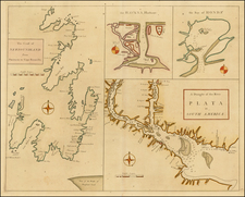
Finely executed manuscript map of the Bay of Jagua (now Bahia de Cienfuegos) on the southern coast of Cuba, executed during a Spanish reconaissance of the harbor in the middle of the 18th Century.
The Bay of Jagua has a rich 500 year history, which includes a brief period as the main base of the Spanish Military Command in 1762, during the period when the English occupied the island. The Bay was visited very early in the history of the island. For example, Pánfilo de Narváez and Alvar Nunez Cabeza de Vaca wintered in the bay in 1527-1528. In the middle of the 16th Century, it was a haven for priates, including Jacques de Sores (1554), Francis Drake (1586), and other more frequent visitors, such as John Morgan, Jean Giron Fearless, and Guillermo Bruce.
The map provides a finely detailed treatment of the Bay and environs, including the Rio Caonas, S. Matheo (on an elegantly drawn hillside), Rio Azinto, Urubi, Rio Salado, Rio Damagi and Alcaldemayez (?), along with local roads, soundings. etc. The Laguna de Guanasaco (Guanaraco) is located.
The map key (lower left) provides details for a number of other places denoted only with letters. The key also provides geographical details on the bay and surrounding rivers.
Several earlier manuscript maps of the harbor were acquired by the Library of Congress (from Maggs Brothers in the 19th Century), which provide similar detailed images of the Bay, although without the stylized hilly images upon which S. Mateo is located: ww.loc.gov/item/91680835 and www.loc.gov/item/91680843 and www.loc.gov/item/91680844 , although these three plans likely pre-date our plan by approximately 50 years, as noted below.
We have dated our plan of Jagua as circa 1750, based upon the location of the Castillo del Nuestra Señora de los Ángeles de Jagua (Castillo del Jagua) on the plan and other important historical events of this time period which would have given rise to an updated charting of the harbor. The 3 maps in the collection of the Library of Congress do not mention Castillo del Jagua, which was constructed between 1733 and 1745 by the French military engineer Don Jose Tantete Duvillier, on orders of the Spanish crown, on foundations that are thought to have been built in 1729 by another engineer; Don Bruno Caballero y Elvira. The castle was constructed as a means of defending the region against pirates.
Upon completion, Castillo del Jagua was the third most important fort on Cuba, after the El Morro Castle in Havana and the El Morro Castle in Santiago de Cuba. In 1762, it was the seat of the Spanish military command, during the brief English occupation of the Island. The first commander of the castle was Don José Castilla Cabeza de Vaca. The castle was equipped with 10 large caliber cannons; four 18-pounders on the uppermost level and four 24-pounders and two 8 pounds on the lower level. The castle still has a functioning wooden drawbridge over a dry moat.
Based upon the relative importance of the harbor, we surmise that the map was prepared sometime between the completion of the Castillo del Jagua in 1745 and its becoming the Seat of the Spanish military command in 1762. We note that Thomas Jefferys' Plan de Bahía Xagua on the south side of Cuba, prepared in 1768, provides a very different mapping of the Bay and almost certainly post-dates this Spanish manuscript plan.
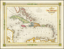

![West Indies and Central America [Bermuda inset]](https://storage.googleapis.com/raremaps/img/small/89941.jpg)