|
||

|

|
|

|
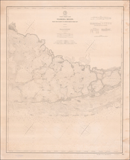
Fine large format map, published in connection with the Second Seminole War.
The map includes a detailed topographical treatment of early Florida roads, U.S. forts, other details of the 2nd Seminole War, and land area assigned to the Seminoles.
There is great detail of Army forts, battlegrounds, Seminole villages, vegetation, hydrology, and a large network of roads and trails; many labeled with the related military action.
Crossed swords are used as an icon to locate battles. The colored line illustrates the District assigned to the Seminoles by the Arrangement of Gen. Macomb on May 18, 1839. The panhandle west of Tallahassee and the Ocklockonee River is not included.
One of the best large format maps of Florida during its territorial period.
![(Florida Aviation - Early Photographs) [Original photograph album of Carlstrom Field, Florida, early Army Air Service Training Camp]](https://storage.googleapis.com/raremaps/img/small/84163.jpg)