|
||

|

|
|

|
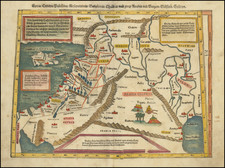
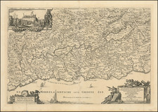
Rare Swedish map of the Holy Land, published in Stockholm in 1588.
The map shows the coast from Sidon to the Nile River Delta, identifying the wanderings of the Israelites in the desert, with 41 different encampments noted. On the right lower side is a cartouche with the names of each encampment.
In the right lower corner is a drawing of the Tabernacle, surrounded by the tents of Moses, Aharon, Merari, Gershon and Kehat, and around them the 12 tribes. The Mediterranean includes a Sea Monster (Jona the Whale?) and sailing ship.
The engraving quality is fascinating, with a fine illustration of the wake being created by the sailing ship.
The map appeared in Itinerarium sacrae scripturae, thet är een reesebook, öffuer then helighe Schrifft, vthi twå böker deelat . . . , a Swedish edition of Bunting's work.
The map is very rare, this being the first example we have ever seen on the market.
![Suite de la Genealogie ou Chronologie des Rois Patriarches et Prophetes du troisieme Periode du Monde. [Cyprus]](https://storage.googleapis.com/raremaps/img/small/91749.jpg)